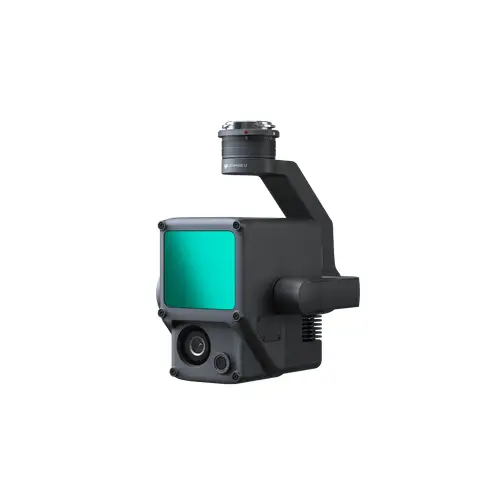

DJI Zenmuse L1
DJI Zenmuse L1 - Instant Clarity. Superior Accuracy.
A Lidar + RGB Solution for Aerial Surveying
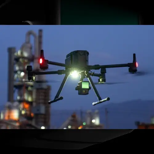
The Zenmuse L1 integrates a Livox Lidar module, a high-accuracy IMU, and a camera with a 1-inch CMOS on a 3-axis stabilized gimbal. When used with Matrice 300 RTK and DJI Terra, the L1 forms a complete solution that gives you real-time 3D data throughout the day, efficiently capturing the details of complex structures and delivering highly accurate reconstructed models.
- Integrates a Lidar module,an RGB camera, and a high-accuracy IMU
- High Efficiency 2 km covered in a single flight
- High Accuracy Vertical Accuracy: 5 cm / Horizontal Accuracy: 10 cm
- Point Rate: 240,000 pts/s
- Supports 3 Returns
- Detection Range: 450 m (80% reflectivity, 0 klx)
- IP54 Ingress Protection Level
- Point Cloud LiveView
Digitize without Compromise
- Exceptional Efficiency: Generate true-color point cloud models in real-time, or acquire 2 km of point cloud data in a single flight using the Livox frame Lidar module with a 70° FOV and a visible light camera with a 1-inch sensor.
- Unparalleled Accuracy: Render centimeter-accurate reconstructions thanks to the high-accuracy IMU, a vision sensor for positioning accuracy, and the incorporation of GNSS data.
- Ready When You Are: The IP54 rating allows the L1 to be operated in rainy or foggy environments. The Lidar module’s active scanning method enables you to fly at night.
Visualize Data as You Fly - Livox Lidar Module
- Frame Lidar with up to 100% effective point cloud results
- Detection Range: 450m (80% reflectivity, 0 klx) / 190 m (10% reflectivity, 100 klx)
- Effective Point Rate: 240,000 pts/s
- Supports 3 Returns
- Non-repetitive scanning pattern, Repetitive scanning pattern
Everything in View - RGB Camera
- 20MP
- 1-inch CMOS
- Mechanical Shutter
Accurate Details at Your Disposal - High-accuracy IMU
- Vision Sensor for Positioning Accuracy
- GNSS, IMU, RGB Data Fusion
Recreate the World in 3D Point Clouds
Point Cloud LiveView
- Real-time point clouds provide immediate insights onsite, so operators are informed to make critical decisions quickly.
- You can also verify fieldwork quality by checking point cloud data immediately after each flight.
One-stop Post-processing
- DJI Terra fuses the IMU and GNSS data for point cloud and visible light calculations, in addition to conducting POS data calculations so you can effortlessly generate reconstructed models and accuracy reports.
1x Gimbal and Camera
1x MicroSD card (64GB)
1x Storage Case
1x Lens Cleaning Cloth
1x DJI Terra Activation Code
Reviews & Ratings
Related products

DJI Zenmuse H20


DJI Zenmuse P1

DJI Zenmuse H20N

DJI Zenmuse L2

DJI Zenmuse H30

DJI Zenmuse H30T

Product Queries (0)
Login or Registerto submit your questions to seller
Other Questions
No none asked to seller yet
Top Selling Products

Osmo Pocket 3 Creater Combo


DJI Matrice 4 Series Battery


Top Selling Products
Osmo Pocket 3 Creater Combo
DJI Matrice 4 Series Battery
About
Contacts
-
Address
Office 203, Al Tayer Commercial Building, Rolla Street, Bur Dubai, UAE
-
Phone
+9714 2238380 / +97150 157 6093
-
Email
-
Whatsapp
My Account
Customer Service
Subscribe to our newsletter for regular updates about Offers, Coupons & more
Follow Us
-
Address
Office 203, Al Tayer Commercial Building, Rolla Street, Bur Dubai, UAE
-
Phone
+9714 2238380 / +97150 157 6093
-
Email
-
Whatsapp