SurveyShield Mapping Bundle – M350 RTK + P1 + Parachute
SurveyShield Mapping Bundle – M350 RTK + Zenmuse P1 + Drone Parachute
High-Precision Aerial Mapping with Built-in Flight Safety
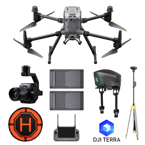
The SurveyShield Mapping Bundle combines the powerful DJI Matrice 350 RTK, the high-resolution Zenmuse P1 photogrammetry payload, and a certified drone parachute system to deliver the most advanced and secure aerial mapping solution in the industry. Built for surveyors, GIS professionals, construction engineers, and government contractors, this bundle ensures accurate geospatial data collection with enhanced flight safety, even during critical missions over populated or high-risk areas.
? Built for Surveying Excellence
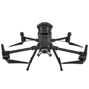
At the core of this package is the DJI Matrice 350 RTK, a next-generation enterprise drone equipped with RTK/PPK technology for centimeter-level positioning accuracy. The aircraft features O3 Enterprise transmission, a 55-minute flight time, and a rugged IP55-rated frame, making it ideal for demanding aerial mapping missions.
Complementing it is the Zenmuse P1, DJI’s most powerful mapping camera. Featuring a 45MP full-frame sensor, interchangeable lenses, and a 3-axis stabilized gimbal, the P1 captures sharp, detailed images that are perfect for generating orthomosaics, 3D models, topographic maps, and point clouds. The camera supports both nadir and oblique capture, optimizing data accuracy even in complex environments.
? Enhanced Safety with Drone Parachute System
What makes the SurveyShield bundle unique is its integration of a certified drone parachute system (e.g., OWL or Flyfire). In the event of a flight failure, the parachute system automatically deploys to slow descent and minimize impact, protecting:
-
The drone and expensive payload (P1)
-
People and property on the ground
-
Your project investment and regulatory compliance
This is especially vital for BVLOS operations, urban surveys, construction site mapping, and publicly accessible zones, where airspace regulations demand enhanced risk mitigation strategies.
⚙️ Key Components & Features
| Component | Details |
|---|---|
| Drone | DJI Matrice 350 RTK – IP55 rated, up to 55 min flight time, RTK/PPK, O3 Enterprise transmission |
| Payload | Zenmuse P1 – 45MP full-frame sensor, global mechanical shutter, 3-axis stabilized gimbal |
| Safety Add-on | Certified Drone Parachute System (OWL or equivalent), auto-deploy, minimal payload impact |
| Software | Compatible with DJI Terra, Pix4D, Agisoft, and other photogrammetry suites |
| Output Deliverables | Orthomosaics, DEM, DSM, 3D models, point clouds, volumetric calculations |
? Applications
✅ Land & Cadastral Surveying
✅ Topographic Mapping
✅ Infrastructure & Road Design
✅ Mining & Quarry Volumetrics
✅ Construction Progress Monitoring
✅ Environmental & Agricultural Assessments
✅ Disaster Mapping and Emergency Planning
? Why Choose the SurveyShield Mapping Bundle?
-
? Unmatched Precision – RTK + P1 ensures industry-grade accuracy
-
? Built-In Safety – Protects drone, payload, and people
-
? Ready for Projects – Ideal for survey firms, GIS companies, and contractors
-
? Global Software Compatibility – Works with your preferred processing suite
-
? Compliance-Ready – Tailored for regulated and BVLOS environments
? Contact AeroSmart Today to learn more, schedule a live demo, or request pricing on the SurveyShield Mapping Bundle.
? sales@aerosmart.ae | ? www.aerosmart.ae
- Dimensions (unfolded, without propellers): 810×670×430 mm (L×W×H)
- Dimensions (folded, with propellers): 430×420×430 mm (L×W×H)
- Diagonal Wheelbase: 895 mm
- Weight (with single downward gimbal)
- Without batteries:
Approx. 3.77 kg - With two TB65 batteries:
Approx. 6.47 kg
- Without batteries:
- Single Gimbal Damper’s Max Payload: 960 g
- Max Takeoff Weight: 9.2 kg
- Operating Frequency
2.4000-2.4835 GHz
5.150-5.250 GHz (CE: 5.170-5.250 GHz)
5.725-5.850 GHz
In some countries and regions, the 5.1GHz and 5.8GHz frequency bands are prohibited, or the 5.1GHz frequency band is only allowed for indoor use. Please refer to local laws and regulations for more information.
- Transmitter Power (EIRP)
2.4000-2.4835 GHz:
< 33 dBm (FCC)
< 20 dBm (CE/SRRC/MIC)
5.150-5.250 GHz (CE: 5.170-5.250 GHz):
< 23 dBm (CE)
5.725-5.850 GHz:
< 33 dBm (FCC/SRRC)
< 14 dBm (CE)
- Hovering Accuracy (with moderate or no wind)
Vertical:
±0.1 m (with vision positioning)
±0.5 m (with GNSS positioning)
±0.1 m (with RTK positioning)
Horizontal:
±0.3 m (with vision positioning)
±1.5 m (with GNSS positioning)
±0.1 m (with RTK positioning)
- RTK Positioning Accuracy (RTK FIX)
1 cm + 1 ppm (horizontal)
1.5 cm + 1 ppm (vertical)
- Max Angular Velocity
Pitch: 300°/s
Yaw: 100°/s
- Max Pitch Angle
30°
When in N mode and with the forward vision system enabled: 25°.
- Max Ascent Speed: 6 m/s
- Max Descent Speed (vertical): 5 m/s
- Max Tilted Descent Speed: 7 m/s
- Max Horizontal Speed: 23 m/s
- Max Flight Altitude
5000 m
When using the 2110s propellers and with the takeoff weight ≤ 7.4 kg.
7000 m
When using the 2112 High-Altitude Low-Noise Propellers and with the takeoff weight ≤ 7.2 kg.
- Max Wind Speed Resistance: 12 m/s
- Max Flight Time
55 minutes
Measured with Matrice 350 RTK flying at approximately 8 m/s without payloads in a windless environment until the battery level reached 0%. Data is for reference only. Actual usage time may vary depending on the flight mode, accessories, and environment. Please pay attention to reminders in the app.
- Supported DJI Gimbals: Zenmuse H20, Zenmuse H20T, Zenmuse H20N, Zenmuse P1, and Zenmuse L1
- Supported Gimbal Configurations
Single downward gimbal
Single upward gimbal
Dual downward gimbals
Single downward gimbal + single upward gimbal
Dual downward gimbals + single upward gimbal
- Ingress Protection Rating
IP55
The IP rating is not permanently effective and may decrease due to product wear and tear.
- Global Navigation Satellite System: GPS + GLONASS + BeiDou + Galileo
- Operating Temperature: -20° to 50° C (-4° to 122° F)
Remote Controller
- Screen: 7.02-inch LCD touchscreen; resolution: 1920×1200; max brightness: 1200 nits
- Weight
Approx. 1.25 kg (without WB37 battery)
Approx. 1.42 kg (with WB37 battery)
- Global Navigation Satellite System: GPS + Galileo + BeiDou
- Built-in Battery
Type: Li-ion (6500 mAh@7.2 V)
Charging Type: Use the battery station or USB-C fast charger with a max power of 65 W (max voltage of 20 V).
Charging Time: 2 hours
Chemical System: LiNiCoAlO2
- External Battery (WB37 Intelligent Battery)
Capacity: 4920 mAh
Voltage: 7.6 V
Type: Li-ion
Energy: 37.39 Wh
Chemical System: LiCoO2
- Ingress Protection Rating: IP54
- Operating Time
Built-in Battery: approx. 3.3 hours
Built-in Battery + External Battery: approx. 6 hours
- Operating Temperature: -20° to 50° C (-4° to 122° F)
- Operating Frequency
2.4000-2.4835 GHz
5.725-5.850 GHz
- Transmitter Power (EIRP)
2.4000-2.4835 GHz:
< 33 dBm (FCC)
< 20 dBm (CE/SRRC/MIC)
5.725-5.850 GHz:
< 33 dBm (FCC)
< 14 dBm (CE)
< 23 dBm (SRRC)
- Wi-Fi Protocol: Wi-Fi 6
- Wi-Fi Operating Frequency
2.4000-2.4835 GHz
5.150-5.250 GHz
5.725-5.850 GHz
- Bluetooth Protocol: Bluetooth 5.1
- Bluetooth Operating Frequency: 2.4000-2.4835 GHz
Video Transmission
- Video Transmission System: DJI O3 Enterprise Transmission
- Antenna: 4 video transmission antennas, 2T4R
- Max Transmission Distance (unobstructed, free of interference)
20 km (FCC)
8 km (CE/SRRC/MIC)
- Max Transmission Distance (with interference)
Low Interference and Obstructed by Buildings: approx. 0-0.5 km
Low Interference and Obstructed by Trees: approx. 0.5-3 km
Strong Interference and Unobstructed: urban landscape, approx. 1.5-3 km
Medium Interference and Unobstructed: suburban landscape, approx. 3-9 km
Low Interference and Unobstructed: suburb/seaside, approx. 9-20 km
Measured with FCC compliance in unobstructed environments with typical interference at a flight altitude of approximately 120 m. Data is for reference only. The actual transmission distance may vary depending on the environment’s obstruction and interference conditions. Please pay attention to reminders in the app.
Vision System
- Obstacle Sensing Range
Forward/Backward/Left/Right: 0.7-40 m
Upward/Downward: 0.6-30 m
- FOV
Forward/Backward/Downward: 65° (horizontal), 50° (vertical)
Left/Right/Upward: 75° (horizontal), 60° (vertical)
- Operating Environment: Surfaces with discernible patterns and adequate lighting (lux > 15)
Infrared Sensing System
- Obstacle Sensing Range: 0.1-8 m
- FOV: 30° (±15°)
- Operating Environment: Large, diffuse, and reflective obstacles (reflectivity > 10%)
LED Auxiliary Light
- Effective Illumination Distance: 5 m
- Illumination Type: 60 Hz, solid glow
FPV Camera
- Resolution: 1080p
- FOV: 142°
- Frame Rate: 30fps
Intelligent Flight Battery
- Model: TB65
- Capacity: 5880 mAh
- Voltage: 44.76 V
- Type: Li-ion
- Energy: 263.2 Wh
- Weight: Approx. 1.35 kg
- Operating Temperature: -20° to 50° C (-4° to 122° F)
- Ideal Storage Temperature: 22° to 30° C (71.6° to 86° F)
- Charging Temperature
-20° to 40° C (-4° to 104° F)
When the ambient temperature is below 5° C (41° F), the battery will trigger the auto-heating function. Charging at low temperatures may reduce battery life. It is recommended to charge at 15° to 35° C (59° to 95° F).
- Charging Time
With a 220V power supply, it takes approximately 60 minutes to fully charge two TB65 Intelligent Flight Batteries and approximately 30 minutes to charge them from 20% to 90%.
With a 110V power supply, it takes approximately 70 minutes to fully charge two TB65 Intelligent Flight Batteries and approximately 40 minutes to charge them from 20% to 90%.
Intelligent Battery Station
- Dimensions: 580×358×254 mm (L×W×H)
- Net Weight: Approx. 8.98 kg
- Compatible Stored Items
Eight TB65 Intelligent Flight Batteries
Four WB37 Intelligent Batteries
- Input Voltage
100-120 VAC, 50-60 Hz
220-240 VAC, 50-60 Hz
- Max Input Power: 1070 W
- Output Power
100-120 V: 750 W
220-240 V: 992 W
- Operating Temperature: -20° to 40° C (-4° to 104° F)
Zenmuse P1
General
- Product Name: Zenmuse P1
- Dimensions: 198×166×129 mm
- Weight: Approx. 787 g
- Power: 13 W
- IP Rating: IP4X
- Supported Aircraft: Matrice 300 RTK
- Operating Temperature Range: -20° to 50° C (-4° to 122° F)
- Storage Temperature Range: -20° to 60° C (-4° to 140° F)
- Absolute Accuracy: Horizontal: 3 cm, Vertical: 5 cm *(Using Mapping Mission at a GSD of 3 cm and flight speed of 15 m/s, with an 75% front overlap rate and a 55% side overlap rate.)
Camera
- Sensor: Sensor size (Still): 35.9×24 mm (Full frame) ; Sensor size (Max video recording area): 34×19 mm ; Effective Pixels: 45MP ; Pixel size: 4.4 μm
- Supported Lenses: DJI DL 24mm F2.8 LS ASPH (with lens hood and balancing ring/filter), FOV 84° ; DJI DL 35mm F2.8 LS ASPH (with lens hood and balancing ring/filter), FOV 63.5° ; DJI DL 50mm F2.8 LS ASPH (with lens hood and balancing ring/filter), FOV 46.8°
- Supported SD Cards: SD: UHS-1 rating or above; Max capacity: 128 GB
- Storage Files: Photo / GNSS Raw Observation Data/ Image Log File
- Photo Size: 3:2 (8192×5460)
- Operation Modes: Capture, Record, Playback
- Minimum photo interval: 0.7 s
- Shutter Speed: Mechanical Shutter Speed: 1/2000-1/8 s ; Electronic Shutter Speed: 1/8000-8 s
- Aperture Range: f/2.8-f/16
- ISO Range: Photo: 100-25600 ; Video: 100-3200
Video
- Video Format: MP4
- Video Resolution: 16:9 (3840×2160)
- Frame Rate: 60fps
Gimbal
- Stabilized System: 3-axis (tilt, roll, pan)
- Angular Vibration Range: 0.01°
- Mount: Detachable DJI SKYPORT
- Mechanical Range: Tilt: -125° to +40°; Roll: -55° to +55°; Pan: ±320°
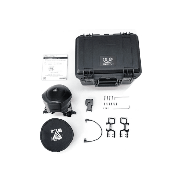
OWL Parachute for DJI Matrice 350 RTK
Adaptation: DJI Matrice 300 RTK / DJI Matrice 350 RTK Product Specifications
Sensor Dual (IMU barometer)
Software APS Algorithm
Connecting Way PSDK interface connection
Parachute cloth type: Square cloth
Protection class: IPX5
Product Performance
Reaction time: 0.8s
Parachute deployment time: 0.3s
Parachute cloth area: 7.29m²
Affects the aircraft’s battery life: 5min
Weight: 800g
Siren: Dual speakers
Paddle stop function: Forced stop
Landing speed: 3.5m/s
Maximum load: 9kg
Drone:
- DJI Matrice 350 RTK
- DJI Zenmuse P1
- D-RTK 2 Ground Station + Tripod
- 2x TB65 Intelligent Battery Station
- 1x BS65 Intelligent Battery Station
- DJI Terra (1 Year)
Landing Pad
- OWL Drone Parachute:
- Parachute System Unit
- Mounting Brackets & Screws
- Cable
- User Manual
- Remote Activation Module
Reviews & Ratings
Related products

DJI Matrice 30T With BS30

")


DJI Matrice 350 TB65 Intelligent Flight Battery

DJI Flycart 30


Product Queries (0)
Login or Registerto submit your questions to seller
Other Questions
No none asked to seller yet
Top Selling Products

Osmo Pocket 3 Creater Combo

DJI Matrice 4 Series Battery
")
DJI Mini 5 Pro Fly More Combo (DJI RC 2)

DJI Neo 2 Motion Fly More Combo

DJI Neo 2 Fly More Combo

DJI Neo 2
Top Selling Products
Osmo Pocket 3 Creater Combo
DJI Matrice 4 Series Battery
DJI Mini 5 Pro Fly More Combo (DJI RC 2)
DJI Neo 2 Motion Fly More Combo
DJI Neo 2 Fly More Combo
DJI Neo 2
About
Empowering industries with cutting-edge drone technology, DJI Enterprise solutions, and expert support across the UAE and beyond.
Contacts
-
Address
Office 203, Al Tayer Commercial Building, Rolla Street, Bur Dubai, UAE
-
Phone
+9714 2238380 / +97150 157 6093
-
Email
-
Whatsapp
My Account
Customer Service
Subscribe to our newsletter for regular updates about Offers, Coupons & more
Follow Us
Empowering industries with cutting-edge drone technology, DJI Enterprise solutions, and expert support across the UAE and beyond.
-
Address
Office 203, Al Tayer Commercial Building, Rolla Street, Bur Dubai, UAE
-
Phone
+9714 2238380 / +97150 157 6093
-
Email
-
Whatsapp