DJI Mavic 3 Enterprise Precision Surveying and Mapping Combo
DJI Mavic
3 Enterprise Precision Surveying and Mapping Combo: Unmatched Efficiency and
Accuracy
In the fast-paced world of modern surveying and mapping, the
DJI Mavic 3 Enterprise Precision Surveying and Mapping Combo stands out as a
revolutionary tool designed to elevate precision, efficiency, and accuracy to
new heights. This comprehensive package combines the powerful capabilities of
the DJI Mavic 3 Enterprise drone with advanced surveying technology, making it
an indispensable asset for professionals across various industries.
Exceptional
Aerial Performance
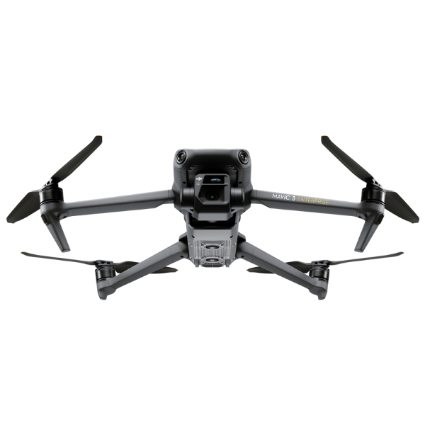
The DJI Mavic 3 Enterprise is engineered for top-tier
performance, featuring a powerful propulsion system that ensures stability and
reliability even in challenging environments. With a maximum flight time of up
to 45 minutes, the Mavic 3 Enterprise allows for extensive aerial surveys
without the need for frequent battery changes. Its robust design and advanced
obstacle sensing technology enable safe and efficient operations, even in
complex and cluttered environments.
High-Precision
GNSS and RTK Technology
Accuracy is paramount in surveying and mapping, and the
Mavic 3 Enterprise excels in this area with its integrated high-precision GNSS
and RTK technology. This allows the drone to achieve centimeter-level
positioning accuracy, essential for creating precise and reliable maps and
models. Whether it's for topographic mapping, land surveying, or construction
site monitoring, the Mavic 3 Enterprise ensures that every detail is captured
with exceptional precision.
Advanced
Imaging Capabilities
Equipped with a high-resolution camera featuring a 4/3 CMOS
sensor, the Mavic 3 Enterprise captures stunningly detailed images and videos.
The camera supports a variety of shooting modes, including single shot, burst
shooting, and time-lapse, providing versatile options for different surveying
needs. The ability to capture high-quality imagery from the air allows
professionals to generate detailed orthomosaic maps, 3D models, and accurate
point clouds for comprehensive analysis and decision-making.
Seamless
Integration with Surveying Software
The Mavic 3 Enterprise Precision Surveying and Mapping Combo
is designed to work seamlessly with leading surveying software, including DJI
Terra and other third-party applications. This integration streamlines the
workflow, from mission planning and data capture to post-processing and
analysis. The software offers advanced features such as automated flight
routes, real-time data visualization, and precise georeferencing, ensuring a
smooth and efficient surveying process.
Enhanced
Efficiency and Cost-Effectiveness
Traditional surveying methods can be time-consuming and
labor-intensive. The Mavic 3 Enterprise dramatically improves efficiency by
covering large areas in a fraction of the time required by ground-based
methods. Its ability to fly at high speeds and capture extensive data in a
single flight significantly reduces operational costs. Additionally, the ease
of deployment and user-friendly interface make it accessible to both
experienced surveyors and newcomers to drone technology.
Versatility
Across Industries
The Mavic 3 Enterprise Precision Surveying and Mapping Combo
is highly versatile, making it suitable for a wide range of applications. In
construction, it can be used for site inspections, progress monitoring, and
volume measurements. In agriculture, it helps in crop monitoring, field
mapping, and precision farming. In environmental management, it assists in
forest management, wildlife monitoring, and disaster assessment. The drone's
adaptability to various industries underscores its value as a multipurpose
tool.
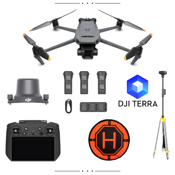
Comprehensive
Package for Complete Solutions
The Mavic 3 Enterprise Precision Surveying and Mapping Combo
includes everything needed for professional surveying and mapping:
·
DJI Mavic 3 Enterprise drone
·
High-resolution 4/3 CMOS camera
·
RTK module for centimeter-level accuracy
·
Intelligent Flight Batteries for extended
missions
·
DJI Terra software for advanced data processing
·
Additional accessories for enhanced
functionality
Conclusion
For professionals seeking to enhance their surveying and
mapping capabilities, the DJI Mavic 3 Enterprise Precision Surveying and
Mapping Combo offers an unparalleled solution. Its advanced features,
high-precision technology, and seamless integration with surveying software
make it the ultimate tool for achieving accurate, efficient, and cost-effective
results. Embrace the future of surveying and mapping with the DJI Mavic 3
Enterprise, and unlock new possibilities in your field. Aerosmart UAV is the official
DJI Enterprise dealer in Dubai, UAE. For more details, contact +971501576093.
1x DJI Mavic 3 Enterprise
3x Baterries
1x Battery Charging Hub
1x RTK Module
1x D-RTK 2 Mobile Base Station & Tripod
1x DJI RC Pro Enterprise
1x DJI Terra Pro ( 1year )
1x Landing Pad
Reviews & Ratings
Related products

DJI Matrice 30T With BS30

")


DJI Matrice 350 TB65 Intelligent Flight Battery

DJI Flycart 30


Product Queries (0)
Login or Registerto submit your questions to seller
Other Questions
No none asked to seller yet
Top Selling Products

Osmo Pocket 3 Creater Combo

DJI Matrice 4 Series Battery

DJI Neo 2 Fly More Combo
")
DJI Mini 5 Pro Fly More Combo (DJI RC 2)

DJI Neo 2 Motion Fly More Combo

DJI Neo 2
Top Selling Products
Osmo Pocket 3 Creater Combo
DJI Matrice 4 Series Battery
DJI Neo 2 Fly More Combo
DJI Mini 5 Pro Fly More Combo (DJI RC 2)
DJI Neo 2 Motion Fly More Combo
DJI Neo 2
About
Empowering industries with cutting-edge drone technology, DJI Enterprise solutions, and expert support across the UAE and beyond.
Contacts
-
Address
Office 203, Al Tayer Commercial Building, Rolla Street, Bur Dubai, UAE
-
Phone
+9714 2238380 / +97150 157 6093
-
Email
-
Whatsapp
My Account
Customer Service
Subscribe to our newsletter for regular updates about Offers, Coupons & more
Follow Us
Empowering industries with cutting-edge drone technology, DJI Enterprise solutions, and expert support across the UAE and beyond.
-
Address
Office 203, Al Tayer Commercial Building, Rolla Street, Bur Dubai, UAE
-
Phone
+9714 2238380 / +97150 157 6093
-
Email
-
Whatsapp