DJI Matrice 400 Ultimate Public Safety Package
DJI Matrice 400 Ultimate Public Safety Package
Complete Aerial Solution for Emergency Response, Law Enforcement, and Crisis Management
When every second counts, and situational awareness is critical, public safety agencies need a drone platform that is powerful, reliable, and ready for rapid deployment. The DJI Matrice 400 Ultimate Public Safety Package is a complete turnkey solution designed specifically for fire departments, police forces, emergency responders, and disaster management teams. This advanced aerial platform integrates high-performance hardware, intelligent payloads, multi-gimbal flexibility, and real-time operational software—delivering unmatched visibility, control, and response accuracy.
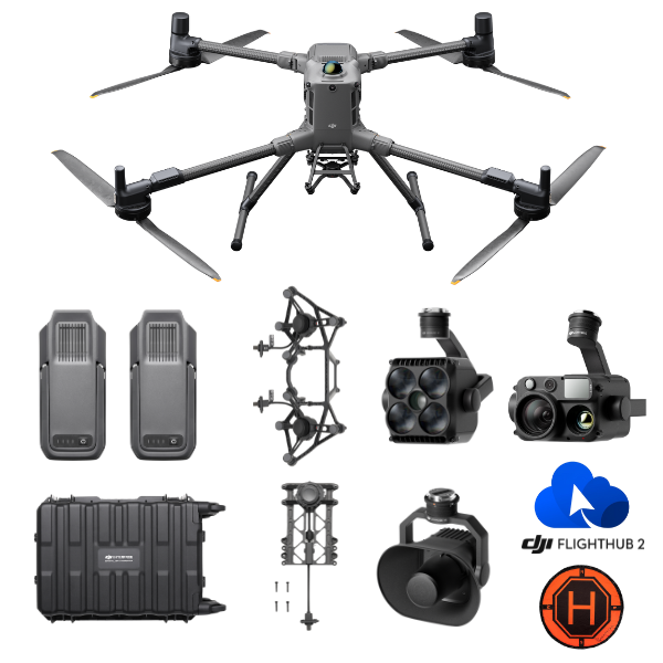
What’s Included in the Package
-
DJI Matrice 400 drone (1 unit)
-
TB100 Intelligent Flight Batteries (2 units)
-
Dual Gimbal Connector for M400 (1 unit)
-
Third Gimbal Connector for M400 (1 unit)
-
DJI Zenmuse H30T Thermal & Visual Payload (1 unit)
-
DJI Zenmuse S1 Spotlight (1 unit)
-
DJI Zenmuse Z1 Loudspeaker (1 unit)
-
1-Year FlightHub 2 Software Subscription
-
Landing Pad for safe takeoff and landing (1 unit)
-
WB37 Intelligent Batteries for RC Plus (2 units)
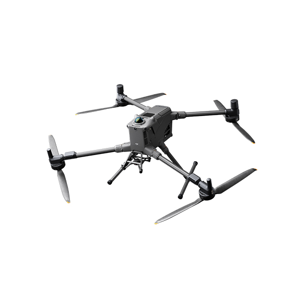
Meet the DJI Matrice 400 – Core of the Package
At the heart of this package is the DJI Matrice 400, DJI's latest flagship enterprise drone. This next-generation aircraft is engineered for long-endurance missions, multi-payload integration, and rugged field operations. With a flight time of up to 50+ minutes (depending on payload), IP55-rated weather resistance, and hot-swappable dual batteries, the M400 delivers rock-solid performance in the most demanding public safety environments.
Key Features:
-
IP55 Weather Resistance – Fly confidently in rain, dust, and extreme environments.
-
RTK and High-Precision GPS – Essential for accurate mapping and navigation in rescue zones or crime scenes.
-
Long-Range Transmission – Stable O3 Enterprise video and command link for over 15 km of range.
-
Advanced Obstacle Avoidance – 360° sensing system ensures safe navigation around structures or during night operations.
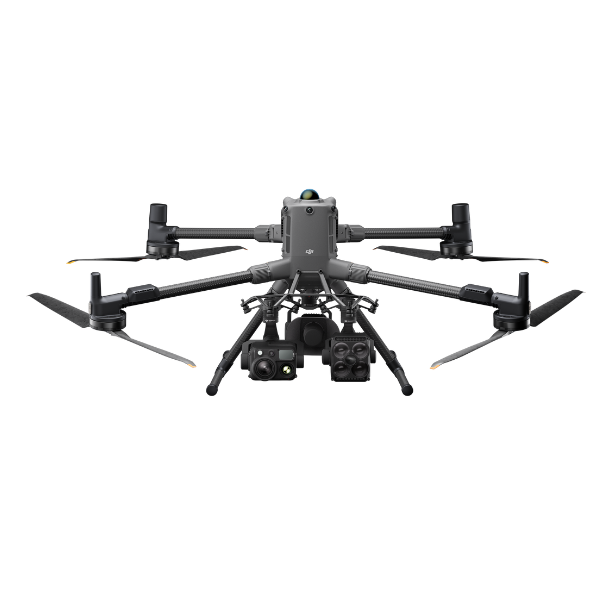
DJI Zenmuse H30T Payload – Advanced Multi-Sensor Imaging
The Zenmuse H30T is DJI’s most advanced public safety payload to date. It combines a 40MP wide camera, 200x max zoom, thermal imaging, laser rangefinder, and night vision—all in a single stabilized gimbal.
Why It Matters:
-
Thermal Camera (640 x 512) – Detect people, hotspots, or fires through smoke and darkness.
-
Laser Rangefinder (1,200m) – Mark targets and calculate distances with pinpoint accuracy.
-
Starlight Night Vision – See clearly in ultra-low-light environments during search operations.
-
AI Object Tracking – Automatically track people or vehicles across wide operational zones.
This camera is ideal for fire monitoring, missing person searches, hostage situations, crowd monitoring, and post-disaster assessments.
Zenmuse S1 Spotlight – Illuminate the Mission
The DJI S1 Spotlight enhances low-light and night-time visibility with a powerful focused beam. Essential for illuminating accident scenes, rescue zones, or ground targets, the S1 allows ground teams and aerial observers to coordinate during night missions with high visual clarity.
Features:
-
120W power output
-
Adjustable beam angle
-
Up to 150m effective illumination range
-
Controlled directly via DJI Pilot 2 interface
Zenmuse Z1 Speaker – Command and Communication
Crisis communication is vital. The DJI Z1 speaker allows remote operators to broadcast messages or warnings clearly over long distances. Whether directing a crowd, communicating with lost individuals, or issuing emergency instructions, the Z1 is a critical tool in public interaction.
-
Clear audio transmission over 200m
-
Supports custom audio file uploads
-
Live voice broadcast via RC Plus
-
Lightweight and rugged
Multi-Gimbal Setup – Greater Coverage, More Data
This package includes a dual gimbal connector and a third gimbal connector, enabling the Matrice 400 to carry up to three payloads simultaneously. You can operate the H30T, spotlight, and loudspeaker in tandem, maximizing aerial awareness and operational flexibility.
Real-Time Operations with FlightHub 2
A 1-year subscription to DJI FlightHub 2 is included, giving your command center the power to monitor live missions, access geo-tagged data, and collaborate in real time.
FlightHub 2 Benefits:
-
Cloud-based mission planning and coordination
-
Real-time video feeds from the drone
-
Map annotation, team coordination, and flight history logs
-
Secure data management and sharing across departments
Enhanced Operational Support
-
Landing Pad – Ensures takeoff and landing safety on rough or dusty terrain.
-
2 x WB37 Batteries – Power your RC Plus controllers or charging stations for uninterrupted command operation.
Ideal Use Cases for Public Safety
1. Firefighting & Wildfire Response
-
Monitor spread patterns with thermal imaging
-
Coordinate ground crews with live video and voice commands
-
Fly in smoky or low-visibility environments with obstacle sensing
2. Law Enforcement & Surveillance
-
Track suspects or vehicles with AI-powered zoom
-
Broadcast messages during evacuations or standoffs
-
Collect aerial evidence and scene documentation
3. Search & Rescue
-
Use thermal cameras to locate missing persons
-
Illuminate search zones with the S1 spotlight
-
Direct teams using the Z1 speaker from above
4. Disaster Response
-
Assess infrastructure damage post-flood or earthquake
-
Deploy multiple payloads for simultaneous imaging and communication
-
Share mission data with citywide coordination via FlightHub 2
Aircraft
Takeoff Weight (with propellers)
- Without Batteries: 5020±20 g
With Batteries: 9740±40 g
The actual product weight may vary due to differences in batch materials and external factors.
Max Takeoff Weight
- 15.8 kg
Dimensions
- Unfolded: 980×760×480 mm (L×W×H) (with landing gear)
Folded: 490×490×480 mm (L×W×H) (with landing gear and gimbal)
Maximum dimensions excluding propellers.
Aircraft carrying case dimensions: 779×363×528 mm (L×W×H)
Max Payload
- 6 kg
The 6 kg payload is measured at the third gimbal connector under sea level conditions. Payload capacity decreases as altitude increases. For details, refer to the official user manual.
Propeller Size
- 25 inches
Diagonal Wheelbase
- 1070 mm
Max Ascent Speed
- 10 m/s
Max Descent Speed
- 8 m/s
Max Horizontal Speed (at sea level, no wind)
- 25 m/s
Max Takeoff Altitude
- 7000 m
Max Flight Time (no wind)
- 59 minutes
Measured with the aircraft flying forward at a constant speed of 10 m/s in a windless environment at sea level, carrying only the H30T (total weight 10,670 g), and from 100% battery level until 0%. Data is for reference only. Actual experience may vary depending on the environment, usage, and firmware version.
Max Hover Time (no wind)
- 53 minutes
Measured with the aircraft hovering in a windless environment at sea level, carrying only the H30T (total weight 10,670 g), and from 100% battery level until 0%. Data is for reference only. Actual usage time may vary depending on the flight mode, accessories, and environment.
Max Flight Distance (no wind)
- 49 km
Measured by the aircraft flying forward at a constant speed of 17 m/s in a windless environment at sea level, without external payloads, and from 100% battery level until 0%. Actual experience may vary depending on the environment, usage, and firmware version.
Max Wind Speed Resistance
- 12 m/s
Max wind speed resistance during takeoff and landing.
Max Yaw Angular Velocity
- Yaw: 100°/s
Max Pitch Angle
- 35°
Operating Temperature
- -20° to 50° C (-4° to 122° F) (without solar radiation)
Global Navigation Satellite System (GNSS)
- GPS + Galileo + BeiDou + GLONASS*
* GLONASS is supported only when the RTK module is enabled.
Equipped with standard airborne ADS-B In receiver and dual antennas, supporting reception up to 20 km.
Hovering Accuracy Range (with moderate or no wind)
- Vertical:
±0.1 m (with vision positioning)
±0.5 m (with satellite positioning)
±0.1 m (with RTK positioning)
Horizontal:
±0.3 m (with vision positioning)
±0.5 m (with satellite positioning)
±0.1 m (with RTK positioning)
RTK GNSS Accuracy
- RTK Fix:
1 cm + 1 ppm (horizontal), 1.5 cm + 1 ppm (vertical)
RTK Heading
- Supports RTK heading with an accuracy better than 2°
Airborne ADS-B In
- Equipped with standard airborne ADS-B In receiver and dual antennas, supporting reception up to 20 km.
Internal Storage
- N/A
Ports
- USB-C Debug Port × 1: USB 2.0
E-Port V2 × 4: At the lower part of the drone, with 120W single-port power
Cellular Dongle 2 Interface × 2: On the underside of the drone
Propeller Model
- 2510F
Beacon
- Built into the aircraft
Ingress Protection Rating
- IP55
The rating is not permanently effective and may decrease due to product wear and tear.
Gimbal
Maximum Payload for Single Gimbal Connector
- 1400 g
If exceeds, the gimbal damper lifespan will decrease from 1000 hours to 400 hours.
Maximum Payload for Dual Gimbal Connector
- 950 g
Maximum Payload for Third Gimbal Connector
- 3 kg for quick-release port, 6 kg for screw lock fastening
Sensing
Sensing Type
- Omnidirectional binocular vision system (surround view provided by full-color fisheye vision sensors)
Horizontal rotating LiDAR, upper LiDAR and downward 3D infrared range sensor
Six-direction mmWave radar
Forward
- Measurement Range: 0.4-21 m
Detection Range: 0.4-200 m
Field of View (FOV): 90° (horizontal), 90° (vertical)
Backward
- Measurement Range: 0.4-21 m
Detection Range: 0.4-200 m
Field of View (FOV): 90° (horizontal), 90° (vertical)
Lateral
- Measurement Range: 0.6-21 m
Detection Range: 0.5-200 m
Field of View (FOV): 90° (horizontal), 90° (vertical)
Downward
- Measurement Range: 0.5-19 m
The FOV to the front and rear is 160° and 105° to the right and left.
Operating Environment
- Forward, Backward, Left, Right, and Upward:
Delicate texture on the surface, adequate light.
Downward:
The ground has rich textures and sufficient lighting conditions*, with a diffuse reflection surface and a reflectivity greater than 20% (such as walls, trees, people, etc.).
* Sufficient lighting conditions refer to an illuminance not lower than that of a nighttime city light scene.
Rotating LiDAR
- Standard Measurement Range: 0.5-100 m @ 100,000 lux with 10% reflectivity target
Measurement Range for Power Line: 35 m @ 30° @ 10,000 lux for 21.6 mm steel-core aluminum stranded wire with a relative body tilt angle of 30° to the left and right
Field of View (FOV): 360° (horizontal), 58° (vertical)
Point-Frequency: 520,000 points/second
Laser Wavelength: 905 nm
Eye Safety Level: Class 1 (IEC60825-1:2014), eye-safe
Upper LiDAR (3D ToF)
- 0.5-25 m at night (reflectivity > 10%)
The FOV to the up and down is 60° and 60° to the right and left.
Downward 3D Infrared Range Sensor
- Measurement Range: 0.3-8 m (reflectivity > 10%)
The FOV to the front and rear is 60° and 60° to the right and left.
mmWave Radar
- Measurement Range for Power Line:
36 m for a 12.5mm steel-core aluminum stranded wire
50 m for a 21.6mm steel-core aluminum stranded wire
FOV: ± 45° (horizontal and vertical)
The mmWave radar function is unavailable in some countries/regions.
FPV Camera
Resolution
- 1080p
Field of View (FOV)
- DFOV: 150°
HFOV: 139.6°
VFOV: 95.3°
Frame Rate
- 30fps
Night Vision
- Starlight Grade
Video Transmission
Video Transmission System
- DJI O4 Enterprise Enhanced Video Transmission System
Live View Quality
- Remote Controller: 3-channel 1080p/30fps
Operating Frequency and Transmitter Power (EIRP)
- 902-928 MHz: < 30 dBm (FCC), < 16 dBm (MIC)
1.430-1.444 GHz: < 35 dBm (SRRC)
2.4000-2.4835 GHz: < 33 dBm (FCC), < 20 dBm (CE/SRRC/MIC)
5.150-5.250 GHz: < 23 dBm (FCC/CE)
5.725-5.850 GHz: < 33 dBm (FCC), < 14 dBm (CE), < 30 dBm (SRRC)
Operating frequency allowed varies among countries and regions. Refer to local laws and regulations for more information.
Max Transmission Distance (unobstructed, free of interference)
- 40 km (FCC)
20 km (CE/SRRC/MIC)
Measured in an unobstructed environment free of interference. The above data shows the farthest communication range for one-way, non-return flights under each standard. During your flight, please pay attention to RTH reminder on the DJI Pilot 2 app.
Max Transmission Distance (with interference)
- Strong interference (dense buildings, residential areas, etc.): approx. 1.5-6 km
Medium interference (suburban counties, city parks, etc.): approx. 6-15 km
Weak interference (open spaces, remote areas, etc.): approx. 15-40 km
Data is tested under FCC standard in unobstructed environments of typical interference. Only to serve as a reference and provides no guarantee as to the actual flight distance.
Max Download Speed
- Standard Mode: 80Mbps Downlink
Playback Download: < 25 MBps
Single-Channel Bitrate: ≤ 12 Mbps
The above data was measured under conditions where the aircraft and remote controller were in close proximity without interference.
Antenna
- WLAN Antenna × 8: 6 vertically polarized antennas and 2 horizontally polarized antennas
sub2G Antenna × 2: 2 vertically polarized antennas
4G Antenna × 4
Operating Mode: 2T4R
Others
- Supports Dual Control Mode and 2-channel Cellular Dongle 2
Battery
Model
- TB100
Capacity
- 20254 mAh
Standard Voltage
- 48.23 V
Max Charging Voltage
- 54.6 V
Cell Type
- Li-ion 13S
Energy
- 977 Wh
Weight
- 4720 ± 20 g
Charging Temperature
- 5° to 45° C (41° to 113° F)
Discharging Temperature
- -20° to 75° C (-4° to 122° F)
Battery Heating
- Single Battery: Support
Onboard: Support
Battery Station: Support
Discharge Rate
- 4C
Max Charging Power
- 2C
Low-Temperature Charging
- Supports low-temperature self-heating charging
Cycle Count
- 400
Intelligent Battery Station
Model
- BS100
Net Weight
- 11.8 kg
Dimensions
- 605×410×250 mm (L×W×H)
Supported Batteries
- TB100 Intelligent Flight Battery, TB100C Tethered Battery
WB37 Battery
Operating Temperature
- -20° to 40° C (-4° to 104° F)
Input
- 100-240 V (AC), 50-60 Hz, 10 A
Output
- USB-C:
TB100 Battery Interface:
100-110 V: Approx. 1185 W
110-180 V: Approx.1474 W
180-240 V: Approx. 2184 W
WB37 Battery Interface:
100-240 V: Approx. 52 W
USB-C:
5.0 V 3.0 A, 9.0 V 3.0 A, 12.0 V 3.0 A, 15.0 V 3.0 A, 20.0 V 3.25 A
Number of Charging Channels
- Three TB100 and two WB37 batteries
Charging Mode
- Ready-to-Fly Mode 90%; Standard Mode 100%
Supports Fast Charging Mode and Silent Mode
Charging Time
- TB100/TB100C Battery From 0% to 100%:
220 V: 45 minutes (Fast Charging Mode); 110 minutes (Silent Mode)
110 V: 70 minutes (Fast Charging Mode); 110 minutes (Silent Mode)
Charging time is measured in a test environment with a temperature of 25° C.
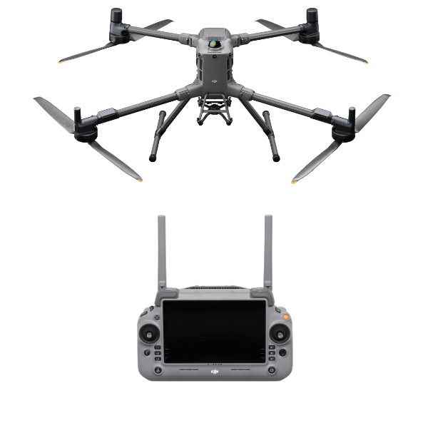
DJI RC Plus 2 Enterprise Enhanced
Video Transmission System
- DJI O4 Enterprise Enhanced Video Transmission System
Max Transmission Distance (unobstructed, free of interference)
- 40 km (FCC)
20 km (CE/SRRC/MIC)
Measured in an unobstructed environment free of interference. The above data shows the farthest communication range for one-way, non-return flights under each standard. During your flight, please pay attention to RTH reminder on the DJI Pilot 2 app.
Video Transmission Operating Frequency and Transmitter Power (EIRP)
- 902-928 MHz: < 30 dBm (FCC), < 16 dBm (MIC)
2.400-2.4835 GHz: < 33 dBm (FCC), < 20 dBm (CE/SRRC/MIC)
5.150-5.250 GHz: < 23 dBm (FCC/CE)
5.725-5.850 GHz: < 33 dBm (FCC), < 14 dBm (CE), < 30 dBm (SRRC)
Operating frequency allowed varies among countries and regions. Refer to local laws and regulations for more information.
Antenna
- 2T4R, 2.4GHz/5.8GHz multi-beam high-gain antenna
sub2G Module: 2T2R
Enhanced Transmission
- Supports DJI Cellular Dongle 2
Wi-Fi Protocol
- Wi-Fi Direct, Wireless Display, IEEE 802.11 a/b/n/ac/ax
Supports 2×2 MIMO Wi-Fi, dual-band simultaneous (DBS) support for dual MAC, with data rates up to 1774.5 Mbps (2×2 + 2×2 11ax dual-band simultaneous)
Wi-Fi Operating Frequency
- 2.4000-2.4835 GHz
5.150-5.250 GHz
5.725-5.850 GHz
5.2 and 5.8GHz frequencies are prohibited in some countries. In some countries, the 5.2GHz frequency is only allowed for use in indoor.
Wi-Fi Transmitter Power (EIRP)
- 2.4 GHz: < 26 dBm, < 20 dBm (CE/SRRC/MIC)
5.1 GHz: < 23 dBm (FCC/CE/SRRC/MIC)
5.8 GHz: < 23 dBm (FCC/SRRC), < 14 dBm (CE)
Bluetooth Protocol
- Bluetooth 5.2
Bluetooth Operating Frequency
- 2.400-2.4835 GHz
Bluetooth Transmitter Power (EIRP)
- < 10 dBm
Screen Resolution
- 1920 × 1200
Screen Size
- 7.02 inches
Screen Frame Rate
- 60fps
Brightness
- 1400 nits
Touchscreen Control
- 10-Point Multi-Touch
Built-in Battery
- 2S2P High Energy Density 18650 Lithium-ion Battery (6500 mAh @ 7.2 V) 46.8 Wh
External Battery
- Optional, WB37 (4920 mAh @ 7.6 V) 37 Wh
Charging Type
- Supports PD fast charging, with a maximum 20V/3.25A USB Type-C charger
Storage Capacity
- RAM 8G + ROM 128G UFS + expandable storage via microSD card
Charging Time
- 2 hours for internal battery; 2 hours for internal plus external batteries.
When remote controller is powered off and using a standard DJI charger.
Internal Battery Runtime
- 3.8 hours
External Battery Runtime
- 3.2 hours
Output Port
- HDMI 1.4
Indicators
- Status LED, battery level LED, connection status LED, tricolor light, brightness adjustable according to ambient light
Speaker
- Supports buzzer
Audio
- Array MIC
Operating Temperature
- -20° to 50° C (-4° to 122° F)
Storage Temperature
- Within one month: -30° to 45° C (-22° to 140° F)
One to three months: -30° to 35° C (-22° to 113° F)
Three months to one year: -30° to 30° C (-22° to 86° F)
Charging Temperature
- 5° to 40° C (41° to 104° F)
Supported Aircraft Model
- Matrice 400
Global Navigation Satellite System
- GPS + Galileo + BeiDou
Dimensions
- 268×163×94.5 mm (L×W×H)
Width including external antenna folded, thickness including handle and controller sticks.
Weight
- 1.15 kg (without external battery)
Model
- TKPL 2
System Version
- Android 11
External Interfaces
- HDMI 1.4, SD 3.0, USB-C with OTG support, max 65W PD charging, USB-A with USB 2.0 support
Accessories
- Strap/waist support
Supported Products
DJI Products Compatible With Matrice 400
- Gimbal Cameras: Zenmuse H30, Zenmuse H30T, Zenmuse L2 and Zenmuse P1
Accessories: Zenmuse S1 (drone spotlight), Zenmuse V1 (drone speaker), Manifold 3, DJI RC Plus 2 sub2G SDR Module, DJI Cellular Dongle 2
RTK Station: D-RTK 3 Multifunctional Station, D-RTK 2 Mobile Station
Ecosystem Accessories: DJI X-Port
DJI E-Port V2 Development Kit
DJI E-Port V2 Coaxial Cable Kit
DJI SKYPORT V3 Adapter Set
DJI SKYPORT V3 Coaxial Cable Kit
1x DJI Matrice 400 drone
2x TB100 Intelligent Flight Batteries
1x Dual Gimbal Connector for M400
1x Third Gimbal Connector for M400
1x DJI Zenmuse H30T Thermal & Visual Payload
1x DJI Zenmuse S1 Spotlight
1x DJI Zenmuse Z1 Loudspeaker
1x 1-Year FlightHub 2 Software Subscription
1x Landing Pad for safe takeoff and landing
2x WB37 Intelligent Batteries for RC Plus
Reviews & Ratings
Related products

DJI Matrice 30T With BS30

")


DJI Matrice 350 TB65 Intelligent Flight Battery

DJI Flycart 30


Product Queries (0)
Login or Registerto submit your questions to seller
Other Questions
No none asked to seller yet
Top Selling Products

Osmo Pocket 3 Creater Combo

DJI Matrice 4 Series Battery
")
DJI Mini 5 Pro Fly More Combo (DJI RC 2)

DJI Neo 2 Motion Fly More Combo

DJI Neo 2 Fly More Combo

DJI Neo 2
Top Selling Products
Osmo Pocket 3 Creater Combo
DJI Matrice 4 Series Battery
DJI Mini 5 Pro Fly More Combo (DJI RC 2)
DJI Neo 2 Motion Fly More Combo
DJI Neo 2 Fly More Combo
DJI Neo 2
About
Empowering industries with cutting-edge drone technology, DJI Enterprise solutions, and expert support across the UAE and beyond.
Contacts
-
Address
Office 203, Al Tayer Commercial Building, Rolla Street, Bur Dubai, UAE
-
Phone
+9714 2238380 / +97150 157 6093
-
Email
-
Whatsapp
My Account
Customer Service
Subscribe to our newsletter for regular updates about Offers, Coupons & more
Follow Us
Empowering industries with cutting-edge drone technology, DJI Enterprise solutions, and expert support across the UAE and beyond.
-
Address
Office 203, Al Tayer Commercial Building, Rolla Street, Bur Dubai, UAE
-
Phone
+9714 2238380 / +97150 157 6093
-
Email
-
Whatsapp