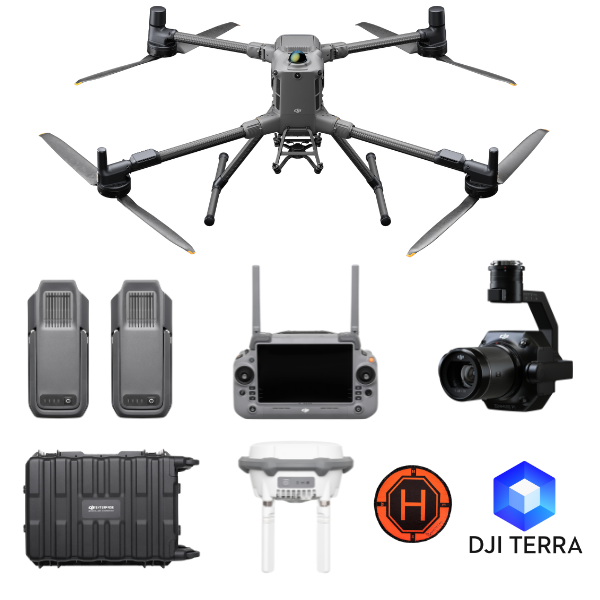
DJI Matrice 400 Precision Mapper Kit
DJI Matrice 400 3D Mapping Package – Precision Redefined for Modern Geospatial Intelligence
Advanced Aerial Surveying and 3D Modeling Solution for Professional Mappers, Surveyors, and GIS Teams
The demand for high-accuracy mapping and efficient data capture has never been greater. Whether you're mapping urban infrastructure, conducting topographic surveys, or creating 3D terrain models, professionals need a platform that delivers both reliability and precision. The DJI Matrice 400 3D Mapping Package is a comprehensive, enterprise-grade solution designed to fulfill the most demanding geospatial requirements with speed, accuracy, and flexibility.
This premium package combines the power of the DJI Matrice 400 drone with a cutting-edge camera payload, RTK positioning, mapping accessories, and software compatibility. Ideal for land surveyors, construction professionals, mining engineers, city planners, and GIS service providers, the package enables highly accurate aerial photogrammetry and seamless 3D modeling.
What’s Included in the DJI Matrice 400 3D Mapping Package
-
DJI Matrice 400 Drone
-
2 x TB100 Intelligent Flight Batteries
-
1 x Zenmuse P1 Full-Frame Mapping Camera
-
1 x Dual Gimbal Connector
-
1 x DJI D-RTK 3 High-Precision GNSS Base Station
-
1 x Landing Pad
-
1 x 1-Year DJI Terra Pro License
-
2 x WB37 Batteries for Remote Controller
-
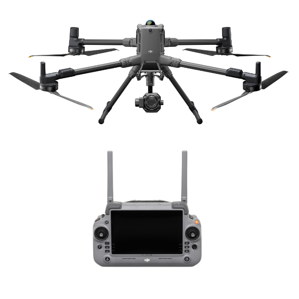
1 x DJI RC Plus 2 Enterprise Remote Controller
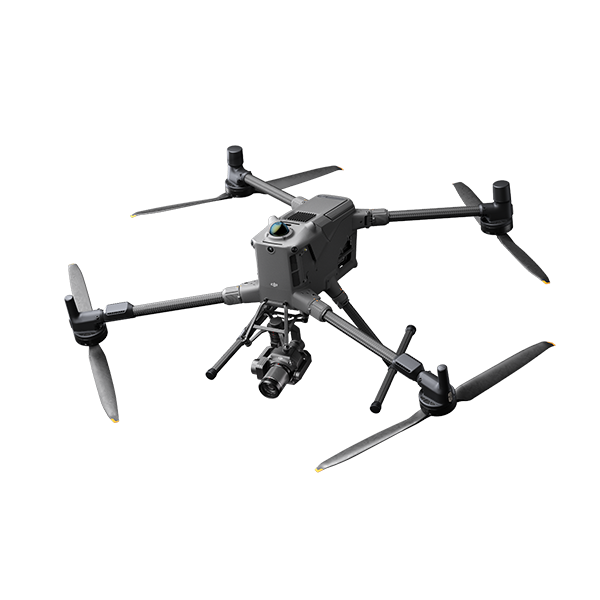
Core Aircraft – DJI Matrice 400: A New Standard for Enterprise Surveying
At the center of this package is the DJI Matrice 400, the most advanced mapping and surveying drone platform in DJI’s enterprise fleet. With an upgraded propulsion system, extended flight times, and robust payload capacity, the M400 is purpose-built for large-area data collection, corridor mapping, and orthophoto missions.
Key Flight Features:
-
Max Flight Time: Up to 55 minutes depending on payload
-
Transmission System: O3 Enterprise with stable control over 20 km range
-
IP55 Rated Weather Resistance: Suitable for operations in rain, dust, and extreme temperatures
-
RTK Module Compatibility: Built-in support for centimeter-level positioning
-
Obstacle Avoidance: 360° omni-directional sensors for safe, automated mapping missions
With a lightweight yet rugged frame, redundant systems, and AI-enhanced flight safety, the M400 ensures accurate data collection even in complex terrains and challenging environments.
Zenmuse P1 – Full-Frame Photogrammetry Camera for Absolute Accuracy
The Zenmuse P1 is DJI’s flagship camera for high-end surveying. Featuring a full-frame 45MP sensor, global mechanical shutter, and interchangeable lenses, it is tailor-made for aerial photogrammetry and 3D modeling.
Camera Highlights:
-
Sensor: 45MP full-frame CMOS
-
Global Mechanical Shutter: 1/2000s for distortion-free image capture
-
Lens Compatibility: Supports 24mm, 35mm, and 50mm lenses
-
Image Accuracy: Achieves 3cm horizontal and 5cm vertical accuracy
-
Smart Oblique Capture: Automated capture of oblique images for 3D models
-
TimeSync 2.0: Synchronizes camera, flight controller, RTK, and gimbal down to microseconds
Perfect for generating orthomosaics, digital surface models (DSMs), and 3D reconstructions, the P1 sets a new benchmark in survey-grade drone imaging.
D-RTK 3 Base Station – Centimeter-Level Precision
For surveyors, accuracy is everything. The D-RTK 3 High-Precision GNSS Station is a multi-constellation, multi-frequency base station designed to work seamlessly with the Matrice 400. It ensures centimeter-level positioning by enabling real-time corrections to flight data.
Key Benefits:
-
Multi-GNSS support (GPS, GLONASS, Beidou, Galileo)
-
Fixed deployment version with tripod for stable operations
-
Quick pairing with aircraft via DJI Pilot 2
-
Compatible with NTRIP networks and supports PPK workflows
DJI Terra Pro Software – From Flight to Digital Twin
A 1-Year License of DJI Terra Pro is included, offering advanced photogrammetry capabilities from mission planning to processing and analysis.
Software Capabilities:
-
3D Modeling: Generate high-resolution textured mesh models
-
Orthomosaic Generation: Create true-to-scale aerial maps
-
Volume Calculation: Measure stockpile or excavation volumes
-
Point Cloud Generation: Classify and edit point clouds
-
Seamless Integration: Automatically imports data from Matrice 400 + P1
-
Terrain Awareness: Flight planning based on elevation data
This makes it easier than ever to deliver accurate maps, 3D reconstructions, and actionable spatial data to stakeholders.
Dual Gimbal Connector – Ready for Future Payload Integration
Included in the package is the Dual Gimbal Connector, allowing for the future integration of thermal sensors, LIDAR modules, or loudspeakers if needed. This ensures scalability and allows multi-sensor missions for clients needing both mapping and inspection in one flight.
Extended Endurance – TB100 & WB37 Batteries
The TB100 Intelligent Batteries provide flight endurance of up to 55 minutes, essential for mapping larger areas with fewer flights. These batteries feature smart management, quick charging, and dual battery redundancy.
Also included are 2 WB37 batteries to power the RC Plus controller and accessories during field operations.
Application Use Cases
1. Land Surveying and Topographic Mapping
Capture orthophotos and terrain models with sub-centimeter accuracy for boundary definitions, site planning, and engineering layouts.
2. Construction Site Monitoring
Track site progress, perform volume measurements, and ensure accurate cut/fill calculations using 3D modeling tools.
3. Mining and Quarry Mapping
Generate digital elevation models and volumetric reports for mineral stockpiles, pit boundaries, and safety assessments.
4. Urban Planning and Infrastructure
Plan roads, utilities, and zoning maps with accurate terrain and 3D building models using oblique photogrammetry.
5. Environmental Monitoring
Survey protected landscapes, forests, coastlines, or agricultural plots for change detection, erosion, or development.
Key Technical Specifications
| Component | Specification Summary |
|---|---|
| Drone | DJI Matrice 400 – Max 55 mins, IP55, O3 Enterprise, RTK-ready |
| Camera | Zenmuse P1 – 45MP Full-frame, global shutter, 3cm accuracy |
| Base Station | D-RTK 3 – GNSS multi-constellation RTK with tripod |
| Software | DJI Terra Pro – 1 Year license for mapping, modeling, analytics |
| Battery | 2 x TB100 Intelligent Flight Batteries + 2 x WB37 Controller Batteries |
| Controller | DJI RC Plus 2 – High-brightness touchscreen, customizable controls |
| Accessory | Landing Pad – Safe takeoff and landing for any environment |
Advantages of the DJI Matrice 400 3D Mapping Package
-
Survey-Grade Accuracy – Achieve centimeter-level precision without extensive ground control
-
Rapid Deployment – Complete projects in hours instead of days with minimal manpower
-
All-in-One Solution – Hardware, software, positioning, and camera—all in one package
-
Time & Cost Savings – Reduce field time, eliminate manual measurements, and accelerate project delivery
-
Scalability – Upgradeable with LIDAR, multispectral cameras, or thermal payloads for new projects
-
Compliance Ready – Meets global standards for aerial surveying and inspection
Aircraft
Takeoff Weight (with propellers)
- Without Batteries: 5020±20 g
With Batteries: 9740±40 g
The actual product weight may vary due to differences in batch materials and external factors.
Max Takeoff Weight
- 15.8 kg
Dimensions
- Unfolded: 980×760×480 mm (L×W×H) (with landing gear)
Folded: 490×490×480 mm (L×W×H) (with landing gear and gimbal)
Maximum dimensions excluding propellers.
Aircraft carrying case dimensions: 779×363×528 mm (L×W×H)
Max Payload
- 6 kg
The 6 kg payload is measured at the third gimbal connector under sea level conditions. Payload capacity decreases as altitude increases. For details, refer to the official user manual.
Propeller Size
- 25 inches
Diagonal Wheelbase
- 1070 mm
Max Ascent Speed
- 10 m/s
Max Descent Speed
- 8 m/s
Max Horizontal Speed (at sea level, no wind)
- 25 m/s
Max Takeoff Altitude
- 7000 m
Max Flight Time (no wind)
- 59 minutes
Measured with the aircraft flying forward at a constant speed of 10 m/s in a windless environment at sea level, carrying only the H30T (total weight 10,670 g), and from 100% battery level until 0%. Data is for reference only. Actual experience may vary depending on the environment, usage, and firmware version.
Max Hover Time (no wind)
- 53 minutes
Measured with the aircraft hovering in a windless environment at sea level, carrying only the H30T (total weight 10,670 g), and from 100% battery level until 0%. Data is for reference only. Actual usage time may vary depending on the flight mode, accessories, and environment.
Max Flight Distance (no wind)
- 49 km
Measured by the aircraft flying forward at a constant speed of 17 m/s in a windless environment at sea level, without external payloads, and from 100% battery level until 0%. Actual experience may vary depending on the environment, usage, and firmware version.
Max Wind Speed Resistance
- 12 m/s
Max wind speed resistance during takeoff and landing.
Max Yaw Angular Velocity
- Yaw: 100°/s
Max Pitch Angle
- 35°
Operating Temperature
- -20° to 50° C (-4° to 122° F) (without solar radiation)
Global Navigation Satellite System (GNSS)
- GPS + Galileo + BeiDou + GLONASS*
* GLONASS is supported only when the RTK module is enabled.
Equipped with standard airborne ADS-B In receiver and dual antennas, supporting reception up to 20 km.
Hovering Accuracy Range (with moderate or no wind)
- Vertical:
±0.1 m (with vision positioning)
±0.5 m (with satellite positioning)
±0.1 m (with RTK positioning)
Horizontal:
±0.3 m (with vision positioning)
±0.5 m (with satellite positioning)
±0.1 m (with RTK positioning)
RTK GNSS Accuracy
- RTK Fix:
1 cm + 1 ppm (horizontal), 1.5 cm + 1 ppm (vertical)
RTK Heading
- Supports RTK heading with an accuracy better than 2°
Airborne ADS-B In
- Equipped with standard airborne ADS-B In receiver and dual antennas, supporting reception up to 20 km.
Internal Storage
- N/A
Ports
- USB-C Debug Port × 1: USB 2.0
E-Port V2 × 4: At the lower part of the drone, with 120W single-port power
Cellular Dongle 2 Interface × 2: On the underside of the drone
Propeller Model
- 2510F
Beacon
- Built into the aircraft
Ingress Protection Rating
- IP55
The rating is not permanently effective and may decrease due to product wear and tear.
Gimbal
Maximum Payload for Single Gimbal Connector
- 1400 g
If exceeds, the gimbal damper lifespan will decrease from 1000 hours to 400 hours.
Maximum Payload for Dual Gimbal Connector
- 950 g
Maximum Payload for Third Gimbal Connector
- 3 kg for quick-release port, 6 kg for screw lock fastening
Sensing
Sensing Type
- Omnidirectional binocular vision system (surround view provided by full-color fisheye vision sensors)
Horizontal rotating LiDAR, upper LiDAR and downward 3D infrared range sensor
Six-direction mmWave radar
Forward
- Measurement Range: 0.4-21 m
Detection Range: 0.4-200 m
Field of View (FOV): 90° (horizontal), 90° (vertical)
Backward
- Measurement Range: 0.4-21 m
Detection Range: 0.4-200 m
Field of View (FOV): 90° (horizontal), 90° (vertical)
Lateral
- Measurement Range: 0.6-21 m
Detection Range: 0.5-200 m
Field of View (FOV): 90° (horizontal), 90° (vertical)
Downward
- Measurement Range: 0.5-19 m
The FOV to the front and rear is 160° and 105° to the right and left.
Operating Environment
- Forward, Backward, Left, Right, and Upward:
Delicate texture on the surface, adequate light.
Downward:
The ground has rich textures and sufficient lighting conditions*, with a diffuse reflection surface and a reflectivity greater than 20% (such as walls, trees, people, etc.).
* Sufficient lighting conditions refer to an illuminance not lower than that of a nighttime city light scene.
Rotating LiDAR
- Standard Measurement Range: 0.5-100 m @ 100,000 lux with 10% reflectivity target
Measurement Range for Power Line: 35 m @ 30° @ 10,000 lux for 21.6 mm steel-core aluminum stranded wire with a relative body tilt angle of 30° to the left and right
Field of View (FOV): 360° (horizontal), 58° (vertical)
Point-Frequency: 520,000 points/second
Laser Wavelength: 905 nm
Eye Safety Level: Class 1 (IEC60825-1:2014), eye-safe
Upper LiDAR (3D ToF)
- 0.5-25 m at night (reflectivity > 10%)
The FOV to the up and down is 60° and 60° to the right and left.
Downward 3D Infrared Range Sensor
- Measurement Range: 0.3-8 m (reflectivity > 10%)
The FOV to the front and rear is 60° and 60° to the right and left.
mmWave Radar
- Measurement Range for Power Line:
36 m for a 12.5mm steel-core aluminum stranded wire
50 m for a 21.6mm steel-core aluminum stranded wire
FOV: ± 45° (horizontal and vertical)
The mmWave radar function is unavailable in some countries/regions.
FPV Camera
Resolution
- 1080p
Field of View (FOV)
- DFOV: 150°
HFOV: 139.6°
VFOV: 95.3°
Frame Rate
- 30fps
Night Vision
- Starlight Grade
Video Transmission
Video Transmission System
- DJI O4 Enterprise Enhanced Video Transmission System
Live View Quality
- Remote Controller: 3-channel 1080p/30fps
Operating Frequency and Transmitter Power (EIRP)
- 902-928 MHz: < 30 dBm (FCC), < 16 dBm (MIC)
1.430-1.444 GHz: < 35 dBm (SRRC)
2.4000-2.4835 GHz: < 33 dBm (FCC), < 20 dBm (CE/SRRC/MIC)
5.150-5.250 GHz: < 23 dBm (FCC/CE)
5.725-5.850 GHz: < 33 dBm (FCC), < 14 dBm (CE), < 30 dBm (SRRC)
Operating frequency allowed varies among countries and regions. Refer to local laws and regulations for more information.
Max Transmission Distance (unobstructed, free of interference)
- 40 km (FCC)
20 km (CE/SRRC/MIC)
Measured in an unobstructed environment free of interference. The above data shows the farthest communication range for one-way, non-return flights under each standard. During your flight, please pay attention to RTH reminder on the DJI Pilot 2 app.
Max Transmission Distance (with interference)
- Strong interference (dense buildings, residential areas, etc.): approx. 1.5-6 km
Medium interference (suburban counties, city parks, etc.): approx. 6-15 km
Weak interference (open spaces, remote areas, etc.): approx. 15-40 km
Data is tested under FCC standard in unobstructed environments of typical interference. Only to serve as a reference and provides no guarantee as to the actual flight distance.
Max Download Speed
- Standard Mode: 80Mbps Downlink
Playback Download: < 25 MBps
Single-Channel Bitrate: ≤ 12 Mbps
The above data was measured under conditions where the aircraft and remote controller were in close proximity without interference.
Antenna
- WLAN Antenna × 8: 6 vertically polarized antennas and 2 horizontally polarized antennas
sub2G Antenna × 2: 2 vertically polarized antennas
4G Antenna × 4
Operating Mode: 2T4R
Others
- Supports Dual Control Mode and 2-channel Cellular Dongle 2
Battery
Model
- TB100
Capacity
- 20254 mAh
Standard Voltage
- 48.23 V
Max Charging Voltage
- 54.6 V
Cell Type
- Li-ion 13S
Energy
- 977 Wh
Weight
- 4720 ± 20 g
Charging Temperature
- 5° to 45° C (41° to 113° F)
Discharging Temperature
- -20° to 75° C (-4° to 122° F)
Battery Heating
- Single Battery: Support
Onboard: Support
Battery Station: Support
Discharge Rate
- 4C
Max Charging Power
- 2C
Low-Temperature Charging
- Supports low-temperature self-heating charging
Cycle Count
- 400
Intelligent Battery Station
Model
- BS100
Net Weight
- 11.8 kg
Dimensions
- 605×410×250 mm (L×W×H)
Supported Batteries
- TB100 Intelligent Flight Battery, TB100C Tethered Battery
WB37 Battery
Operating Temperature
- -20° to 40° C (-4° to 104° F)
Input
- 100-240 V (AC), 50-60 Hz, 10 A
Output
- USB-C:
TB100 Battery Interface:
100-110 V: Approx. 1185 W
110-180 V: Approx.1474 W
180-240 V: Approx. 2184 W
WB37 Battery Interface:
100-240 V: Approx. 52 W
USB-C:
5.0 V 3.0 A, 9.0 V 3.0 A, 12.0 V 3.0 A, 15.0 V 3.0 A, 20.0 V 3.25 A
Number of Charging Channels
- Three TB100 and two WB37 batteries
Charging Mode
- Ready-to-Fly Mode 90%; Standard Mode 100%
Supports Fast Charging Mode and Silent Mode
Charging Time
- TB100/TB100C Battery From 0% to 100%:
220 V: 45 minutes (Fast Charging Mode); 110 minutes (Silent Mode)
110 V: 70 minutes (Fast Charging Mode); 110 minutes (Silent Mode)
Charging time is measured in a test environment with a temperature of 25° C.
DJI RC Plus 2 Enterprise Enhanced
Video Transmission System
- DJI O4 Enterprise Enhanced Video Transmission System
Max Transmission Distance (unobstructed, free of interference)
- 40 km (FCC)
20 km (CE/SRRC/MIC)
Measured in an unobstructed environment free of interference. The above data shows the farthest communication range for one-way, non-return flights under each standard. During your flight, please pay attention to RTH reminder on the DJI Pilot 2 app.
Video Transmission Operating Frequency and Transmitter Power (EIRP)
- 902-928 MHz: < 30 dBm (FCC), < 16 dBm (MIC)
2.400-2.4835 GHz: < 33 dBm (FCC), < 20 dBm (CE/SRRC/MIC)
5.150-5.250 GHz: < 23 dBm (FCC/CE)
5.725-5.850 GHz: < 33 dBm (FCC), < 14 dBm (CE), < 30 dBm (SRRC)
Operating frequency allowed varies among countries and regions. Refer to local laws and regulations for more information.
Antenna
- 2T4R, 2.4GHz/5.8GHz multi-beam high-gain antenna
sub2G Module: 2T2R
Enhanced Transmission
- Supports DJI Cellular Dongle 2
Wi-Fi Protocol
- Wi-Fi Direct, Wireless Display, IEEE 802.11 a/b/n/ac/ax
Supports 2×2 MIMO Wi-Fi, dual-band simultaneous (DBS) support for dual MAC, with data rates up to 1774.5 Mbps (2×2 + 2×2 11ax dual-band simultaneous)
Wi-Fi Operating Frequency
- 2.4000-2.4835 GHz
5.150-5.250 GHz
5.725-5.850 GHz
5.2 and 5.8GHz frequencies are prohibited in some countries. In some countries, the 5.2GHz frequency is only allowed for use in indoor.
Wi-Fi Transmitter Power (EIRP)
- 2.4 GHz: < 26 dBm, < 20 dBm (CE/SRRC/MIC)
5.1 GHz: < 23 dBm (FCC/CE/SRRC/MIC)
5.8 GHz: < 23 dBm (FCC/SRRC), < 14 dBm (CE)
Bluetooth Protocol
- Bluetooth 5.2
Bluetooth Operating Frequency
- 2.400-2.4835 GHz
Bluetooth Transmitter Power (EIRP)
- < 10 dBm
Screen Resolution
- 1920 × 1200
Screen Size
- 7.02 inches
Screen Frame Rate
- 60fps
Brightness
- 1400 nits
Touchscreen Control
- 10-Point Multi-Touch
Built-in Battery
- 2S2P High Energy Density 18650 Lithium-ion Battery (6500 mAh @ 7.2 V) 46.8 Wh
External Battery
- Optional, WB37 (4920 mAh @ 7.6 V) 37 Wh
Charging Type
- Supports PD fast charging, with a maximum 20V/3.25A USB Type-C charger
Storage Capacity
- RAM 8G + ROM 128G UFS + expandable storage via microSD card
Charging Time
- 2 hours for internal battery; 2 hours for internal plus external batteries.
When remote controller is powered off and using a standard DJI charger.
Internal Battery Runtime
- 3.8 hours
External Battery Runtime
- 3.2 hours
Output Port
- HDMI 1.4
Indicators
- Status LED, battery level LED, connection status LED, tricolor light, brightness adjustable according to ambient light
Speaker
- Supports buzzer
Audio
- Array MIC
Operating Temperature
- -20° to 50° C (-4° to 122° F)
Storage Temperature
- Within one month: -30° to 45° C (-22° to 140° F)
One to three months: -30° to 35° C (-22° to 113° F)
Three months to one year: -30° to 30° C (-22° to 86° F)
Charging Temperature
- 5° to 40° C (41° to 104° F)
Supported Aircraft Model
- Matrice 400
Global Navigation Satellite System
- GPS + Galileo + BeiDou
Dimensions
- 268×163×94.5 mm (L×W×H)
Width including external antenna folded, thickness including handle and controller sticks.
Weight
- 1.15 kg (without external battery)
Model
- TKPL 2
System Version
- Android 11
External Interfaces
- HDMI 1.4, SD 3.0, USB-C with OTG support, max 65W PD charging, USB-A with USB 2.0 support
Accessories
- Strap/waist support
Supported Products
DJI Products Compatible With Matrice 400
- Gimbal Cameras: Zenmuse H30, Zenmuse H30T, Zenmuse L2 and Zenmuse P1
Accessories: Zenmuse S1 (drone spotlight), Zenmuse V1 (drone speaker), Manifold 3, DJI RC Plus 2 sub2G SDR Module, DJI Cellular Dongle 2
RTK Station: D-RTK 3 Multifunctional Station, D-RTK 2 Mobile Station
Ecosystem Accessories: DJI X-Port
DJI E-Port V2 Development Kit
DJI E-Port V2 Coaxial Cable Kit
DJI SKYPORT V3 Adapter Set
DJI SKYPORT V3 Coaxial Cable Kit
1 x DJI Matrice 400 Drone
1 x BS100 Intelligent Battery Station
2 x TB100 Intelligent Flight Batteries
1 x Zenmuse P1 Full-Frame Mapping Camera
1 x DJI D-RTK 3 High-Precision GNSS Base Station
1 x Landing Pad
1 x 1-Year DJI Terra Pro License
2 x WB37 Batteries for Remote Controller
1 x DJI RC Plus 2 Enterprise Remote Controller
Reviews & Ratings
Related products

DJI Matrice 30T With BS30

")


DJI Matrice 350 TB65 Intelligent Flight Battery

DJI Flycart 30


Product Queries (0)
Login or Registerto submit your questions to seller
Other Questions
No none asked to seller yet
Top Selling Products

Osmo Pocket 3 Creater Combo

DJI Matrice 4 Series Battery
")
DJI Mini 5 Pro Fly More Combo (DJI RC 2)

DJI Neo 2 Motion Fly More Combo

DJI Neo 2 Fly More Combo

DJI Neo 2
Top Selling Products
Osmo Pocket 3 Creater Combo
DJI Matrice 4 Series Battery
DJI Mini 5 Pro Fly More Combo (DJI RC 2)
DJI Neo 2 Motion Fly More Combo
DJI Neo 2 Fly More Combo
DJI Neo 2
About
Empowering industries with cutting-edge drone technology, DJI Enterprise solutions, and expert support across the UAE and beyond.
Contacts
-
Address
Office 203, Al Tayer Commercial Building, Rolla Street, Bur Dubai, UAE
-
Phone
+9714 2238380 / +97150 157 6093
-
Email
-
Whatsapp
My Account
Customer Service
Subscribe to our newsletter for regular updates about Offers, Coupons & more
Follow Us
Empowering industries with cutting-edge drone technology, DJI Enterprise solutions, and expert support across the UAE and beyond.
-
Address
Office 203, Al Tayer Commercial Building, Rolla Street, Bur Dubai, UAE
-
Phone
+9714 2238380 / +97150 157 6093
-
Email
-
Whatsapp