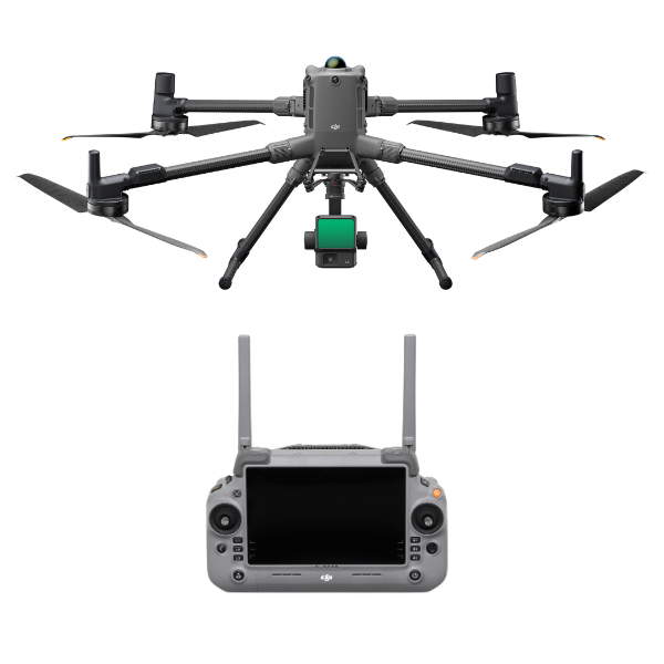
DJI Matrice 400 PowerLine Inspection Kit
M400 PowerLine Pro Inspector Kit
Professional Drone Package for Utility, Power Grid, and Infrastructure Inspection
Overview
The DJI Matrice 400 PowerLine Pro Inspector Kit is a purpose-built drone solution tailored for high-performance inspection and maintenance of electrical infrastructure such as transmission lines, substations, and power towers. Featuring the latest DJI Matrice 400 drone platform, this kit is designed for professionals who demand precision, extended endurance, and reliability in critical missions.
Equipped with industry-leading sensors like the Zenmuse L2 LiDAR and Zenmuse H30T thermal-visual camera, this package ensures you capture precise aerial data across long corridors with minimal downtime. Whether you're scanning high-voltage lines, inspecting transformers, or conducting thermal analysis of electrical assets, the PowerLine Pro Inspector Kit delivers a complete aerial intelligence system built for safety, accuracy, and productivity.
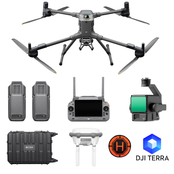
What’s Included in the Kit
-
DJI Matrice 400 Drone
-
Zenmuse L2 LiDAR Payload
-
2x TB100 Intelligent Flight Batteries
-
D-RTK 3 Base Station with Tripod
-
DJI Terra Pro 1 year
-
2x WB37 Batteries (for remote controller)
-
Landing Pad
-
Battery Charging Station
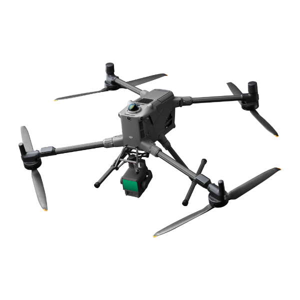
DJI Matrice 400: Flagship Industrial Drone
The DJI Matrice 400 serves as the core of this inspection kit. Built for tough environments and demanding aerial applications, the M400 is engineered for maximum stability, performance, and payload integration.
Key Features:
-
Max Flight Time: Up to 59 minutes (forward flight), 53 minutes (hover)
-
Payload Capacity: Up to 6 kg for multi-sensor configurations
-
IP55 Rating: All-weather resistant (dust, rain, snow, extreme temperatures)
-
Transmission System: O4 Enterprise with up to 40 km range, real-time 1080p 60fps video
-
Obstacle Avoidance: 6-directional sensing, rotating LiDAR and mmWave radar
-
Precision RTK Support: Seamless integration with D-RTK 3 station
-
BVLOS Ready: Advanced comms and failsafe systems for beyond visual line of sight operations
The modular design, hot-swappable batteries, and enhanced stability make the Matrice 400 the ideal platform for long-range utility inspections in any condition.
Zenmuse L2 LiDAR: Corridor Mapping Redefined
The Zenmuse L2 brings powerful aerial LiDAR scanning into the powerline inspection workflow. Built for high-accuracy surveying and 3D corridor modeling, it enables the rapid collection of dense point cloud data while tracking long distances with precision.
Key Benefits:
-
High-Resolution LiDAR with frame-based design
-
4/3-inch CMOS RGB Camera for texture mapping and photogrammetry
-
Integrated IMU and GNSS for absolute position accuracy
-
Real-time 3D Visualization on DJI Pilot 2 app
-
Seamless DJI Terra Processing Compatibility
Operators can scan vast linear infrastructure corridors with fewer flight passes and reduced risk to crews. L2 allows professionals to identify sagging cables, vegetation encroachment, and structure warping more efficiently than ever.
D-RTK 3 Base Station with Tripod
For centimeter-level accuracy, the D-RTK 3 station is included. This high-precision GNSS solution ensures accurate positioning during flights and is critical for PPK/RTK workflows in power grid inspections.
-
Multi-constellation support (GPS, GLONASS, Galileo, BeiDou)
-
Rugged tripod for quick field deployment
-
Compatible with both real-time corrections and offline processing
Batteries and Power Management
-
2x TB100 Intelligent Batteries: 55.2 V high-performance Li-ion batteries with hot-swapping for uninterrupted operations.
-
2x WB37 Batteries: Powering the DJI RC Plus remote controller for extended ground control time.
-
DJI BS100 Charging Station: Charges multiple TB100 batteries simultaneously, optimizing time in the field.
Use Case Scenarios
1. Transmission Line Inspection
Scan kilometers of overhead power lines using L2 LiDAR to model line sag, measure tower spacing, and detect anomalies.
2. Substation Monitoring
Use the H30T thermal camera to monitor heat signatures on transformers, switchgear, and circuit breakers for early fault detection.
3. Infrastructure Mapping
Generate 3D maps of power corridors for digital twin modeling, asset documentation, and urban planning purposes.
4. Vegetation Management
LiDAR point clouds and optical zoom identify encroaching trees or structures that pose risks to powerline integrity.
5. Emergency Response
Post-storm assessment of transmission lines and utility damage with quick deployment and accurate documentation for rapid repairs.
Benefits of the M400 PowerLine Pro Inspector Kit
-
Significantly reduce downtime and maintenance costs
-
Minimize risk by keeping human inspectors away from dangerous infrastructure
-
Enable faster decision-making with accurate real-time and post-flight data
-
Comply with industry inspection standards through automated, repeatable workflows
-
Improve operational efficiency and scalability across multiple sites and teams
Aircraft
Takeoff Weight (with propellers)
- Without Batteries: 5020±20 g
With Batteries: 9740±40 g
The actual product weight may vary due to differences in batch materials and external factors.
Max Takeoff Weight
- 15.8 kg
Dimensions
- Unfolded: 980×760×480 mm (L×W×H) (with landing gear)
Folded: 490×490×480 mm (L×W×H) (with landing gear and gimbal)
Maximum dimensions excluding propellers.
Aircraft carrying case dimensions: 779×363×528 mm (L×W×H)
Max Payload
- 6 kg
The 6 kg payload is measured at the third gimbal connector under sea level conditions. Payload capacity decreases as altitude increases. For details, refer to the official user manual.
Propeller Size
- 25 inches
Diagonal Wheelbase
- 1070 mm
Max Ascent Speed
- 10 m/s
Max Descent Speed
- 8 m/s
Max Horizontal Speed (at sea level, no wind)
- 25 m/s
Max Takeoff Altitude
- 7000 m
Max Flight Time (no wind)
- 59 minutes
Measured with the aircraft flying forward at a constant speed of 10 m/s in a windless environment at sea level, carrying only the H30T (total weight 10,670 g), and from 100% battery level until 0%. Data is for reference only. Actual experience may vary depending on the environment, usage, and firmware version.
Max Hover Time (no wind)
- 53 minutes
Measured with the aircraft hovering in a windless environment at sea level, carrying only the H30T (total weight 10,670 g), and from 100% battery level until 0%. Data is for reference only. Actual usage time may vary depending on the flight mode, accessories, and environment.
Max Flight Distance (no wind)
- 49 km
Measured by the aircraft flying forward at a constant speed of 17 m/s in a windless environment at sea level, without external payloads, and from 100% battery level until 0%. Actual experience may vary depending on the environment, usage, and firmware version.
Max Wind Speed Resistance
- 12 m/s
Max wind speed resistance during takeoff and landing.
Max Yaw Angular Velocity
- Yaw: 100°/s
Max Pitch Angle
- 35°
Operating Temperature
- -20° to 50° C (-4° to 122° F) (without solar radiation)
Global Navigation Satellite System (GNSS)
- GPS + Galileo + BeiDou + GLONASS*
* GLONASS is supported only when the RTK module is enabled.
Equipped with standard airborne ADS-B In receiver and dual antennas, supporting reception up to 20 km.
Hovering Accuracy Range (with moderate or no wind)
- Vertical:
±0.1 m (with vision positioning)
±0.5 m (with satellite positioning)
±0.1 m (with RTK positioning)
Horizontal:
±0.3 m (with vision positioning)
±0.5 m (with satellite positioning)
±0.1 m (with RTK positioning)
RTK GNSS Accuracy
- RTK Fix:
1 cm + 1 ppm (horizontal), 1.5 cm + 1 ppm (vertical)
RTK Heading
- Supports RTK heading with an accuracy better than 2°
Airborne ADS-B In
- Equipped with standard airborne ADS-B In receiver and dual antennas, supporting reception up to 20 km.
Internal Storage
- N/A
Ports
- USB-C Debug Port × 1: USB 2.0
E-Port V2 × 4: At the lower part of the drone, with 120W single-port power
Cellular Dongle 2 Interface × 2: On the underside of the drone
Propeller Model
- 2510F
Beacon
- Built into the aircraft
Ingress Protection Rating
- IP55
The rating is not permanently effective and may decrease due to product wear and tear.
Gimbal
Maximum Payload for Single Gimbal Connector
- 1400 g
If exceeds, the gimbal damper lifespan will decrease from 1000 hours to 400 hours.
Maximum Payload for Dual Gimbal Connector
- 950 g
Maximum Payload for Third Gimbal Connector
- 3 kg for quick-release port, 6 kg for screw lock fastening
Sensing
Sensing Type
- Omnidirectional binocular vision system (surround view provided by full-color fisheye vision sensors)
Horizontal rotating LiDAR, upper LiDAR and downward 3D infrared range sensor
Six-direction mmWave radar
Forward
- Measurement Range: 0.4-21 m
Detection Range: 0.4-200 m
Field of View (FOV): 90° (horizontal), 90° (vertical)
Backward
- Measurement Range: 0.4-21 m
Detection Range: 0.4-200 m
Field of View (FOV): 90° (horizontal), 90° (vertical)
Lateral
- Measurement Range: 0.6-21 m
Detection Range: 0.5-200 m
Field of View (FOV): 90° (horizontal), 90° (vertical)
Downward
- Measurement Range: 0.5-19 m
The FOV to the front and rear is 160° and 105° to the right and left.
Operating Environment
- Forward, Backward, Left, Right, and Upward:
Delicate texture on the surface, adequate light.
Downward:
The ground has rich textures and sufficient lighting conditions*, with a diffuse reflection surface and a reflectivity greater than 20% (such as walls, trees, people, etc.).
* Sufficient lighting conditions refer to an illuminance not lower than that of a nighttime city light scene.
Rotating LiDAR
- Standard Measurement Range: 0.5-100 m @ 100,000 lux with 10% reflectivity target
Measurement Range for Power Line: 35 m @ 30° @ 10,000 lux for 21.6 mm steel-core aluminum stranded wire with a relative body tilt angle of 30° to the left and right
Field of View (FOV): 360° (horizontal), 58° (vertical)
Point-Frequency: 520,000 points/second
Laser Wavelength: 905 nm
Eye Safety Level: Class 1 (IEC60825-1:2014), eye-safe
Upper LiDAR (3D ToF)
- 0.5-25 m at night (reflectivity > 10%)
The FOV to the up and down is 60° and 60° to the right and left.
Downward 3D Infrared Range Sensor
- Measurement Range: 0.3-8 m (reflectivity > 10%)
The FOV to the front and rear is 60° and 60° to the right and left.
mmWave Radar
- Measurement Range for Power Line:
36 m for a 12.5mm steel-core aluminum stranded wire
50 m for a 21.6mm steel-core aluminum stranded wire
FOV: ± 45° (horizontal and vertical)
The mmWave radar function is unavailable in some countries/regions.
FPV Camera
Resolution
- 1080p
Field of View (FOV)
- DFOV: 150°
HFOV: 139.6°
VFOV: 95.3°
Frame Rate
- 30fps
Night Vision
- Starlight Grade
Video Transmission
Video Transmission System
- DJI O4 Enterprise Enhanced Video Transmission System
Live View Quality
- Remote Controller: 3-channel 1080p/30fps
Operating Frequency and Transmitter Power (EIRP)
- 902-928 MHz: < 30 dBm (FCC), < 16 dBm (MIC)
1.430-1.444 GHz: < 35 dBm (SRRC)
2.4000-2.4835 GHz: < 33 dBm (FCC), < 20 dBm (CE/SRRC/MIC)
5.150-5.250 GHz: < 23 dBm (FCC/CE)
5.725-5.850 GHz: < 33 dBm (FCC), < 14 dBm (CE), < 30 dBm (SRRC)
Operating frequency allowed varies among countries and regions. Refer to local laws and regulations for more information.
Max Transmission Distance (unobstructed, free of interference)
- 40 km (FCC)
20 km (CE/SRRC/MIC)
Measured in an unobstructed environment free of interference. The above data shows the farthest communication range for one-way, non-return flights under each standard. During your flight, please pay attention to RTH reminder on the DJI Pilot 2 app.
Max Transmission Distance (with interference)
- Strong interference (dense buildings, residential areas, etc.): approx. 1.5-6 km
Medium interference (suburban counties, city parks, etc.): approx. 6-15 km
Weak interference (open spaces, remote areas, etc.): approx. 15-40 km
Data is tested under FCC standard in unobstructed environments of typical interference. Only to serve as a reference and provides no guarantee as to the actual flight distance.
Max Download Speed
- Standard Mode: 80Mbps Downlink
Playback Download: < 25 MBps
Single-Channel Bitrate: ≤ 12 Mbps
The above data was measured under conditions where the aircraft and remote controller were in close proximity without interference.
Antenna
- WLAN Antenna × 8: 6 vertically polarized antennas and 2 horizontally polarized antennas
sub2G Antenna × 2: 2 vertically polarized antennas
4G Antenna × 4
Operating Mode: 2T4R
Others
- Supports Dual Control Mode and 2-channel Cellular Dongle 2
Battery
Model
- TB100
Capacity
- 20254 mAh
Standard Voltage
- 48.23 V
Max Charging Voltage
- 54.6 V
Cell Type
- Li-ion 13S
Energy
- 977 Wh
Weight
- 4720 ± 20 g
Charging Temperature
- 5° to 45° C (41° to 113° F)
Discharging Temperature
- -20° to 75° C (-4° to 122° F)
Battery Heating
- Single Battery: Support
Onboard: Support
Battery Station: Support
Discharge Rate
- 4C
Max Charging Power
- 2C
Low-Temperature Charging
- Supports low-temperature self-heating charging
Cycle Count
- 400
Intelligent Battery Station
Model
- BS100
Net Weight
- 11.8 kg
Dimensions
- 605×410×250 mm (L×W×H)
Supported Batteries
- TB100 Intelligent Flight Battery, TB100C Tethered Battery
WB37 Battery
Operating Temperature
- -20° to 40° C (-4° to 104° F)
Input
- 100-240 V (AC), 50-60 Hz, 10 A
Output
- USB-C:
TB100 Battery Interface:
100-110 V: Approx. 1185 W
110-180 V: Approx.1474 W
180-240 V: Approx. 2184 W
WB37 Battery Interface:
100-240 V: Approx. 52 W
USB-C:
5.0 V 3.0 A, 9.0 V 3.0 A, 12.0 V 3.0 A, 15.0 V 3.0 A, 20.0 V 3.25 A
Number of Charging Channels
- Three TB100 and two WB37 batteries
Charging Mode
- Ready-to-Fly Mode 90%; Standard Mode 100%
Supports Fast Charging Mode and Silent Mode
Charging Time
- TB100/TB100C Battery From 0% to 100%:
220 V: 45 minutes (Fast Charging Mode); 110 minutes (Silent Mode)
110 V: 70 minutes (Fast Charging Mode); 110 minutes (Silent Mode)
Charging time is measured in a test environment with a temperature of 25° C.
DJI RC Plus 2 Enterprise Enhanced
Video Transmission System
- DJI O4 Enterprise Enhanced Video Transmission System
Max Transmission Distance (unobstructed, free of interference)
- 40 km (FCC)
20 km (CE/SRRC/MIC)
Measured in an unobstructed environment free of interference. The above data shows the farthest communication range for one-way, non-return flights under each standard. During your flight, please pay attention to RTH reminder on the DJI Pilot 2 app.
Video Transmission Operating Frequency and Transmitter Power (EIRP)
- 902-928 MHz: < 30 dBm (FCC), < 16 dBm (MIC)
2.400-2.4835 GHz: < 33 dBm (FCC), < 20 dBm (CE/SRRC/MIC)
5.150-5.250 GHz: < 23 dBm (FCC/CE)
5.725-5.850 GHz: < 33 dBm (FCC), < 14 dBm (CE), < 30 dBm (SRRC)
Operating frequency allowed varies among countries and regions. Refer to local laws and regulations for more information.
Antenna
- 2T4R, 2.4GHz/5.8GHz multi-beam high-gain antenna
sub2G Module: 2T2R
Enhanced Transmission
- Supports DJI Cellular Dongle 2
Wi-Fi Protocol
- Wi-Fi Direct, Wireless Display, IEEE 802.11 a/b/n/ac/ax
Supports 2×2 MIMO Wi-Fi, dual-band simultaneous (DBS) support for dual MAC, with data rates up to 1774.5 Mbps (2×2 + 2×2 11ax dual-band simultaneous)
Wi-Fi Operating Frequency
- 2.4000-2.4835 GHz
5.150-5.250 GHz
5.725-5.850 GHz
5.2 and 5.8GHz frequencies are prohibited in some countries. In some countries, the 5.2GHz frequency is only allowed for use in indoor.
Wi-Fi Transmitter Power (EIRP)
- 2.4 GHz: < 26 dBm, < 20 dBm (CE/SRRC/MIC)
5.1 GHz: < 23 dBm (FCC/CE/SRRC/MIC)
5.8 GHz: < 23 dBm (FCC/SRRC), < 14 dBm (CE)
Bluetooth Protocol
- Bluetooth 5.2
Bluetooth Operating Frequency
- 2.400-2.4835 GHz
Bluetooth Transmitter Power (EIRP)
- < 10 dBm
Screen Resolution
- 1920 × 1200
Screen Size
- 7.02 inches
Screen Frame Rate
- 60fps
Brightness
- 1400 nits
Touchscreen Control
- 10-Point Multi-Touch
Built-in Battery
- 2S2P High Energy Density 18650 Lithium-ion Battery (6500 mAh @ 7.2 V) 46.8 Wh
External Battery
- Optional, WB37 (4920 mAh @ 7.6 V) 37 Wh
Charging Type
- Supports PD fast charging, with a maximum 20V/3.25A USB Type-C charger
Storage Capacity
- RAM 8G + ROM 128G UFS + expandable storage via microSD card
Charging Time
- 2 hours for internal battery; 2 hours for internal plus external batteries.
When remote controller is powered off and using a standard DJI charger.
Internal Battery Runtime
- 3.8 hours
External Battery Runtime
- 3.2 hours
Output Port
- HDMI 1.4
Indicators
- Status LED, battery level LED, connection status LED, tricolor light, brightness adjustable according to ambient light
Speaker
- Supports buzzer
Audio
- Array MIC
Operating Temperature
- -20° to 50° C (-4° to 122° F)
Storage Temperature
- Within one month: -30° to 45° C (-22° to 140° F)
One to three months: -30° to 35° C (-22° to 113° F)
Three months to one year: -30° to 30° C (-22° to 86° F)
Charging Temperature
- 5° to 40° C (41° to 104° F)
Supported Aircraft Model
- Matrice 400
Global Navigation Satellite System
- GPS + Galileo + BeiDou
Dimensions
- 268×163×94.5 mm (L×W×H)
Width including external antenna folded, thickness including handle and controller sticks.
Weight
- 1.15 kg (without external battery)
Model
- TKPL 2
System Version
- Android 11
External Interfaces
- HDMI 1.4, SD 3.0, USB-C with OTG support, max 65W PD charging, USB-A with USB 2.0 support
Accessories
- Strap/waist support
Supported Products
DJI Products Compatible With Matrice 400
- Gimbal Cameras: Zenmuse H30, Zenmuse H30T, Zenmuse L2 and Zenmuse P1
Accessories: Zenmuse S1 (drone spotlight), Zenmuse V1 (drone speaker), Manifold 3, DJI RC Plus 2 sub2G SDR Module, DJI Cellular Dongle 2
RTK Station: D-RTK 3 Multifunctional Station, D-RTK 2 Mobile Station
Ecosystem Accessories: DJI X-Port
DJI E-Port V2 Development Kit
DJI E-Port V2 Coaxial Cable Kit
DJI SKYPORT V3 Adapter Set
DJI SKYPORT V3 Coaxial Cable Kit
Reviews & Ratings
Related products

DJI Matrice 30T With BS30

")


DJI Matrice 350 TB65 Intelligent Flight Battery

DJI Flycart 30


Product Queries (0)
Login or Registerto submit your questions to seller
Other Questions
No none asked to seller yet
Top Selling Products

Osmo Pocket 3 Creater Combo

DJI Matrice 4 Series Battery
")
DJI Mini 5 Pro Fly More Combo (DJI RC 2)

DJI Neo 2 Motion Fly More Combo

DJI Neo 2 Fly More Combo

DJI Neo 2
Top Selling Products
Osmo Pocket 3 Creater Combo
DJI Matrice 4 Series Battery
DJI Mini 5 Pro Fly More Combo (DJI RC 2)
DJI Neo 2 Motion Fly More Combo
DJI Neo 2 Fly More Combo
DJI Neo 2
About
Empowering industries with cutting-edge drone technology, DJI Enterprise solutions, and expert support across the UAE and beyond.
Contacts
-
Address
Office 203, Al Tayer Commercial Building, Rolla Street, Bur Dubai, UAE
-
Phone
+9714 2238380 / +97150 157 6093
-
Email
-
Whatsapp
My Account
Customer Service
Subscribe to our newsletter for regular updates about Offers, Coupons & more
Follow Us
Empowering industries with cutting-edge drone technology, DJI Enterprise solutions, and expert support across the UAE and beyond.
-
Address
Office 203, Al Tayer Commercial Building, Rolla Street, Bur Dubai, UAE
-
Phone
+9714 2238380 / +97150 157 6093
-
Email
-
Whatsapp