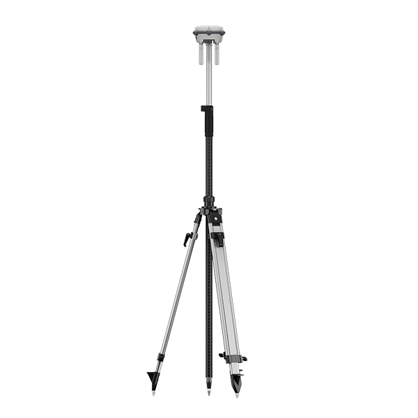
D-RTK 3 Multifunctional Station with Tripod
DJI D-RTK 3 Multifunctional Station – High-Precision GNSS Base for Professional UAV Operations
The DJI D-RTK 3 Multifunctional Station sets a new standard for accuracy, stability, and performance in the world of enterprise drone operations. Built with robust GNSS capabilities and flexible deployment options, this station offers centimeter-level positioning and enhanced compatibility across multiple DJI platforms including the Matrice 350 RTK, Matrice 4 Series, and DJI Dock 3.
This is not just a GNSS base station—it is a multifunctional command module designed to serve as the central nervous system for precision aerial missions. From topographic mapping and infrastructure inspection to search and rescue and border monitoring, the D-RTK 3 Multifunctional Station empowers operators to fly smarter, safer, and with absolute confidence.
Next-Generation RTK Accuracy
Equipped with a multi-frequency GNSS receiver, the D-RTK 3 Station supports GPS, GLONASS, BeiDou, and Galileo, offering fast satellite acquisition, ultra-low latency, and centimeter-level real-time kinematic (RTK) corrections.
The result is remarkably accurate drone positioning—critical for use cases that demand precision such as LiDAR mapping, photogrammetry, and repeatable flight paths for monitoring construction sites or large infrastructure assets. Whether you're executing survey missions or automated patrols, this station ensures every centimeter counts.
Designed for Compatibility and Versatility
The D-RTK 3 Multifunctional Station is engineered to integrate seamlessly with:
-
DJI Matrice 350 RTK
-
DJI Matrice 4 Series (M4D, M4TD, M4T, M4E)
-
DJI Dock 3
-
DJI remote controllers such as the RC Plus
-
DJI FlightHub 2 for fleet-wide integration
Its plug-and-play architecture ensures quick deployment on-site, while intelligent software pairing simplifies the calibration and setup process. It’s a powerful asset for surveyors, first responders, and industrial operators who require real-time positional accuracy across dynamic environments.
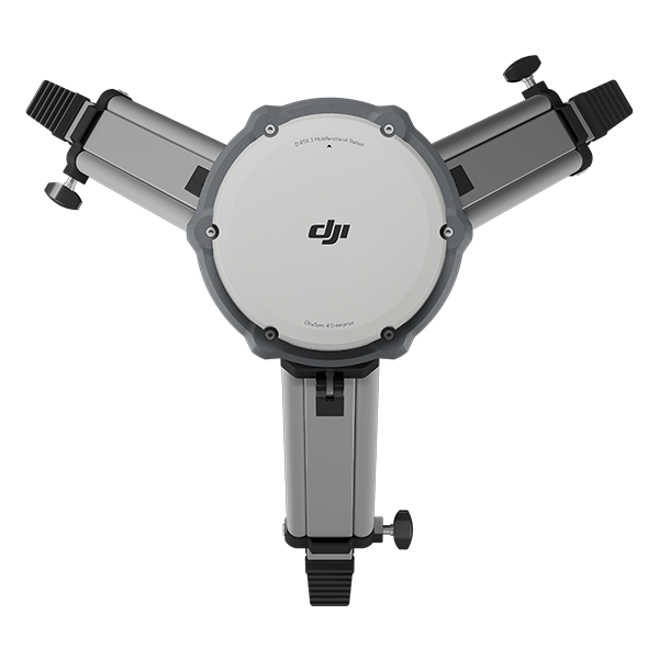
All-in-One Functionality
True to its name, the D-RTK 3 is more than just a GNSS station—it’s a multifunctional platform offering a wide range of applications:
-
RTK Base Station: Acts as the ground-based reference station for RTK corrections
-
Relay Station: Transmits signal to improve communication between drone and remote
-
Fixed Deployment Support: Easily mounted in permanent or semi-permanent installations
-
Real-Time Data Feedback: Syncs with DJI’s cloud platform for live status and diagnostics
With these capabilities in one rugged unit, it reduces the need for multiple pieces of hardware, improving operational efficiency and lowering costs for enterprise drone teams.
Intelligent Battery and Power Options
The station features dual power options, allowing you to run it either from internal high-capacity batteries or an external power source. This flexibility is perfect for both mobile and fixed-location deployments.
-
Hot-swappable batteries allow for non-stop operations
-
Long runtime supports extended field missions
-
Smart power management prevents overheating, overcharging, and voltage drops
Whether you’re conducting long-term missions or short bursts of high-precision activity, this station is ready to deliver consistent results without interruption.
Rugged and Field-Ready Design
The D-RTK 3 Multifunctional Station is built to withstand the toughest environments. With IP65-rated weather resistance, it’s dust-tight, water-resistant, and fully capable of operating in rain, snow, wind, and extreme temperatures ranging from -20°C to 50°C.
Its sturdy casing, durable mounting options, and low-profile design make it ideal for deployment on rooftops, construction scaffolds, vehicles, or dedicated GNSS poles. This station is trusted in remote desert operations, mountainous terrains, coastal zones, and urban megastructures alike.
Seamless Software Integration
The station communicates in real time with DJI’s entire ecosystem of enterprise software platforms:
-
DJI Pilot 2: View RTK status, station position, signal strength, and satellite count directly from the controller
-
DJI FlightHub 2: Monitor multiple stations and connected aircraft simultaneously
-
DJI Terra: Combine RTK-corrected flight logs with photogrammetry software for detailed post-processing
This integration ensures you get not only accurate positioning, but also centralized data management and actionable analytics—essential for large-scale operations and enterprise reporting.
Real-Time Correction Transmission
The D-RTK 3 Station supports Network RTK as well as custom base configurations via NTRIP, making it suitable for operators using CORS (Continuously Operating Reference Station) infrastructure or those needing portable solutions.
With its high-speed data transmission capabilities, it reduces time lags, eliminates drift, and keeps your aircraft locked to exact grid points during complex automated missions.
Use Cases by Industry
Construction and Surveying
Generate accurate terrain models, volumetric calculations, and foundation layouts using RTK-enabled drones connected to the D-RTK 3 Station.
Energy and Utilities
Perform grid inspections, asset documentation, and emergency response missions with improved flight control and location fidelity.
Public Safety
Enhance command-and-control precision during firefighting, disaster response, and search and rescue operations.
Agriculture
Enable field-wide precision crop analysis, multispectral imaging, and geotagged spraying via drones connected to RTK for centimeter-accurate data collection.
Infrastructure and Urban Planning
Monitor progress, map urban zones, and digitize cities with higher positional consistency across survey sessions.
Why Choose DJI D-RTK 3 Multifunctional Station?
-
All-in-one deployment solution: Combines RTK, relay, and power management
-
High precision: Centimeter-level GNSS accuracy ensures mission success
-
Enterprise-level durability: IP65 protection and industrial build quality
-
Seamless DJI integration: Works across Matrice drones, Dock 3, and cloud platforms
-
Reduced human error: Supports fully autonomous workflows with repeatable accuracy
-
Fast ROI: One station covers multiple drone fleets across different sites
GNSS Receiver
GNSS Frequency
- GPS: L1C/A, L2C, L5
BDS: B1I, B2I, B3I, B1C, B2a, B2b
GALILEO: E1, E5a, E5b, E6
GLONASS: L1, L2
QZSS: L1C/A, L2C, L5
L-Band
System Accuracy*
- Base Station Mode (Broadcast Mode) and Relay Station Mode
Base Station Accuracy:
Single Point Accuracy (Uncalibrated):
Horizontal: 1.5 m (RMS)
Vertical: 3.0 m (RMS)
Satellite-Based Differential Accuracy:
Convergence Time: 20 mins
Horizontal: 30 cm (RMS)
Vertical: 40 cm (RMS)
Network RTK Calibration**:
Horizontal: 1.0 cm (RMS) + 1 ppm
Vertical: 3.0 cm (RMS) + 1 ppm
Rover Station Mode*
RTK Accuracy (Fixed Survey):
Horizontal: 0.8 cm (RMS) + 1 ppm
Vertical: 1.5 cm (RMS) + 1 ppm
RTK Accuracy (Tilt Survey)***:
Angle Range: 0° to 60°
Horizontal: 8 mm + 0.7 mm/° tilt (accuracy <2 cm within 30°)
* Measurement accuracy depends on various factors. This value is obtained under normal conditions with an unobstructed view, good satellite distribution, low ionospheric activity, and no electromagnetic interference or multipath effects.
** Base station calibration coordinate accuracy depends on various factors. For surveying, high-precision flight paths, etc., it is recommended to calibrate during periods of inactive ionosphere, in open, unobstructed environments with no electromagnetic interference or multipath effects, using four or more GNSS systems.
*** Intense vibrations and rapid rotations can affect the accuracy of the inertial measurement unit.
Satellite-Based Precise Point Positioning*
- Supported Frequencies: BDS B2b, GALILEO E6**, L-BAND**
Convergence Time: 20 mins
Horizontal: 30 cm (RMS)
Vertical: 40 cm (RMS)
* Measurement accuracy depends on various factors. This value is obtained under normal conditions with an unobstructed view, good satellite distribution, low ionospheric activity, and no electromagnetic interference or multipath effects.
** Will be supported in later versions.
Differential Data Transmission Format
- When used as a base station or relay station, records RTCM 3.2 raw observation data in DAT format.
In rover station mode or in calibration mode for base and relay stations:
1. Supports RTCM v3.0, v3.1, v3.2, v3.3, MSM4, MSM5, MSM6, MSM7 protocols.
2. It is recommended to use receivers that support four or more GNSS systems.
Initialization Reliability
- >99.9%
Video Transmission
Video Transmission System
- O4 Enterprise
Operating Frequency
- Relay Station Mode:
O4: 2.4 GHz/5.2 GHz/5.8 GHz
Base Station Mode:
O4: 2.4 GHz/5.8 GHz
Rover Station Mode:
BLE: 2.4 GHz
Operating frequency allowed varies among countries and regions. Please refer to local laws and regulations for more information.
Transmitter Power (EIRP)
- 2.4000 GHz to 2.4835 GHz:
<33 dBm (FCC)
<20 dBm (CE/SRRC/MIC)
5.150 GHz to 5.250 GHz:
<23 dBm (CE/FCC)
5.725 GHz to 5.850 GHz:
<33 dBm (FCC)
<30 dBm (SRRC)
<14 dBm (CE)
Bluetooth
- Protocol: Bluetooth 5.1
Frequency: 2.400 GHz to 2.4835 GHz
Transmitter Power (EIRP): <10 dBm
Max Transmission Distance (unobstructed, free of interference)
- Base Station Mode
Between D-RTK 3 and the aircraft:
FCC: 15 km
SRRC: 12 km
CE/JP: 8 km
Rover Station Mode:
Between D-RTK 3 and mobile devices: 30 m
Measured in an unobstructed outdoor environment free of interference. The above data shows the farthest communication range for one-way, non-return flights under each standard. Always pay attention to RTH reminders in the app during your flight.
Max Transmission Distance in Relay Station Mode (unobstructed, free of interference)
- FCC
Between the aircraft and the relay station: 25 km
Between the relay station and the remote controller/DJI Dock 3: 1 km
SRRC
Between the aircraft and the relay station: 12 km
Between the relay station and the remote controller/DJI Dock 3: 1 km
CE
Between the aircraft and the relay station: 10 km
Between the relay station and the remote controller/DJI Dock 3: 300 m
Measured in an unobstructed outdoor environment free of interference. The above data shows the farthest communication range for one-way, non-return flights under each standard. Always pay attention to RTH reminders in the app during your flight. The relay station should be placed in a elevated, unobstructed location to ensure clear communication between the remote controller and the aircraft.
Max Transmission Distance (unobstructed, with interference)
- Strong interference: City centers, approx. 1.5-5 km
Medium interference: Suburban areas, approx. 5-15 km
Micro interference: Remote areas/seasides, approx. 15-25 km
Data is tested under FCC standards in unobstructed environments of typical interference. Only to serve as a reference and provides no guarantee as to the actual flight distance.
Max Transmission Distance (obstructed, with interference)
- Low Interference and Obstructed by Buildings: approx. 0-0.5 km
Low Interference and Obstructed by Trees: approx. 0.5-3 km
Data is tested under FCC standards in unobstructed environments of typical interference. Only to serve as a reference and provides no guarantee as to the actual flight distance.
Relay Station Range Extension Effect
- Relay Station Performance Enhancement:
Severe obstruction (e.g., buildings, mountains): 3x to 5x performance improvement
Mild obstruction (e.g., trees, glass): 1x to 3x performance improvement
The relay station must be deployed in an elevated, unobstructed location free of interference.
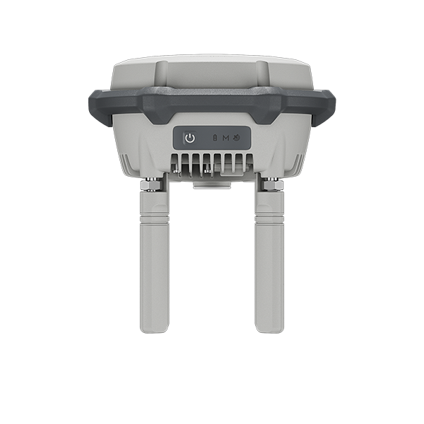
Antenna
- OcuSync 4 directional antennas× 4, 2T4R
The antenna uses a standard reverse polarity SMA connector.
Others
- D-RTK 3 Relay Fixed Deployment Version: Compatible with DJI Cellular Dongle 2
Electrical Properties
Power
- D-RTK 3 Multifunctional Station:
Relay Station: 14.5 W*
Base Station: 7 W
Rover Station: 6.2 W
* Maximum power consumption without heating. When connected to a USB-C power supply above 9V, maximum power consumption with heating is 36.5 W.
D-RTK 3 Relay Fixed Deployment Version:
Relay Station: 14.5 W**
** Max power consumption without heating. When connected to a PoE power supply of Type 4, maximum power consumption with heating is 36.5 W.
Power Output Port
- D-RTK 3 Multifunctional Station: USB Type-C
D-RTK 3 Relay Fixed Deployment Version: USB Type-C and Ethernet Port (PoE)
Supported Power Adapter
- D-RTK 3 Multifunctional Station:
USB PD 3.0 protocol, output voltage 9V to 15V adapter (e.g., DJI 65W Portable Charger)
When using a non-recommended charger, such as a charger with 5V-output, the D-RTK 3 can be charged only after powering off.
D-RTK 3 Relay Fixed Deployment Version:
DJI Dock 3 PoE Output Port
Third-party PoE Power Supplies:
IEEE 802.3bt Type 4 (PoE++): 52 V to 57 V output, 99.9 W max
IEEE 802.3bt Type 3 (PoE++): 50 V to 57 V output, 60 W max
IEEE 802.3at Type 2 (PoE+): 50 V to 57 V output, 30 W max
Battery Operating Time (Under Normal Temperature)*
- D-RTK 3 Multifunctional Station:
Relay Station: 4 hrs
Base Station:7 hrs
Rover Station: 10 hrs
D-RTK 3 Relay Fixed Deployment Version:
Relay Station:4 hrs**
* Battery performance may decrease in low temperatures; it is recommended to use power adapters that support the USB PD 3.0 protocol.
** When powered by PoE, the device battery enters preservation mode and does not fully charge. Upon PoE disconnection, the built-in battery delivers up to 2 hours of runtime.
Ethernet Cable Requirements
- D-RTK 3 Multifunctional Station:
Ethernet not supported
D-RTK 3 Relay Fixed Deployment Version:
Requires Cat 6 twisted-pair cable, ≤100m length, 6-9mm outer diameter.
Battery
- LiPo
Capacity: 6500 mAh
Energy: 46.8 Wh
Physical Characteristics
Operating Temperature
- D-RTK 3 Multifunctional Station: -20° to 55° C (-4° to 131° F)
D-RTK 3 Relay Fixed Deployment Version: -30℃ to 55° C (-22° to 131° F)
1. In normal temperature environments, charging power will be limited if the device shell temperature exceeds 48°C (118.4°F). Full power charging will resume after cooling.
2. After storage/use in low temperatures, the device needs to be brought to a normal temperature environment and allowed to warm up until the internal battery temperature is >0°C (32°F) before charging.
3. After storage/use in high temperatures, the device needs to be brought to a normal temperature environment and allowed to cool down until the internal battery temperature is <45°C (113°F) before charging.
4. When connected to Type 4 PoE power, the D-RTK 3 Relay Fixed Deployment Version enables heating for low-temperature startup.
Altitude
- 6000 m
Protection Rating
- D-RTK 3 Multifunctional Station: IP67*
D-RTK 3 Relay Fixed Deployment Version: IP67**
* Please ensure all rubber seals are securely installed for optimal performance.
** The rubber seal on the PoE input port of the Fixed Deployment Version provides IPX5-rated protection. IP67 protection requires installation of the dedicated PoE port connector and cable.
Drop Resistance
- D-RTK 3 Multifunctional Station: 2 m drop with pole
Dimensions
- D-RTK 3 Multifunctional Station: 163 mm × 89 mm (without OcuSync Directional Antennas)
D-RTK 3 Relay Fixed Deployment Version: 163 mm × 344 mm
Weight
- D-RTK 3 Multifunctional Station: Approx. 1.26 kg (2.78 lbs)
D-RTK 3 Relay Fixed Deployment Version: Approx. 2.24 kg (4.94 lbs)
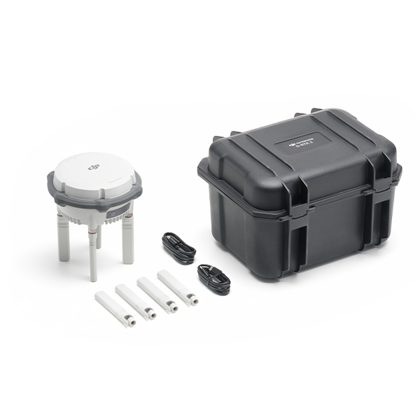
1x D-RTK 3 Multifunction Station
4x Replacement OcuSync Directional Antennas
1x USB-A to USB-C Data Cable
Reviews & Ratings
Related products

DJI Matrice 30T With BS30

")


DJI Matrice 350 TB65 Intelligent Flight Battery

DJI Flycart 30


Product Queries (0)
Login or Registerto submit your questions to seller
Other Questions
No none asked to seller yet
Top Selling Products

Osmo Pocket 3 Creater Combo

DJI Matrice 4 Series Battery
")
DJI Mini 5 Pro Fly More Combo (DJI RC 2)

DJI Neo 2 Motion Fly More Combo

DJI Neo 2 Fly More Combo

DJI Neo 2
Top Selling Products
Osmo Pocket 3 Creater Combo
DJI Matrice 4 Series Battery
DJI Mini 5 Pro Fly More Combo (DJI RC 2)
DJI Neo 2 Motion Fly More Combo
DJI Neo 2 Fly More Combo
DJI Neo 2
About
Empowering industries with cutting-edge drone technology, DJI Enterprise solutions, and expert support across the UAE and beyond.
Contacts
-
Address
Office 203, Al Tayer Commercial Building, Rolla Street, Bur Dubai, UAE
-
Phone
+9714 2238380 / +97150 157 6093
-
Email
-
Whatsapp
My Account
Customer Service
Subscribe to our newsletter for regular updates about Offers, Coupons & more
Follow Us
Empowering industries with cutting-edge drone technology, DJI Enterprise solutions, and expert support across the UAE and beyond.
-
Address
Office 203, Al Tayer Commercial Building, Rolla Street, Bur Dubai, UAE
-
Phone
+9714 2238380 / +97150 157 6093
-
Email
-
Whatsapp